Opening Reflection
What if maps could understand relationships?
For centuries, maps have helped humans answer one question: Where is something located?
But the world we are building today demands a deeper question: Why does that location matter in relation to everything else?
As spatial data becomes increasingly complex, the next evolution of geospatial intelligence may not be better maps, it may be smarter connections between everything on those maps.
Context: The Technological Shift
Over the past decade, digital infrastructure has been built around several powerful technologies, Digital Twins, IoT sensing networks, satellite intelligence, and GeoAI platforms . These systems continuously capture information about the physical world.
A Digital Twin , for example, can represent a physical asset in a virtual environment. It can show the condition of a bridge, the performance of a pump in a water network, or the operational state of an airport terminal.
Yet even the most advanced Digital Twin often answers only two questions:
What is happening?
Where is it happening?
The challenge emerges when organizations need to understand how different systems influence one another .
Infrastructure, environment, supply chains, and urban systems are not isolated. They operate as interconnected networks of relationships .
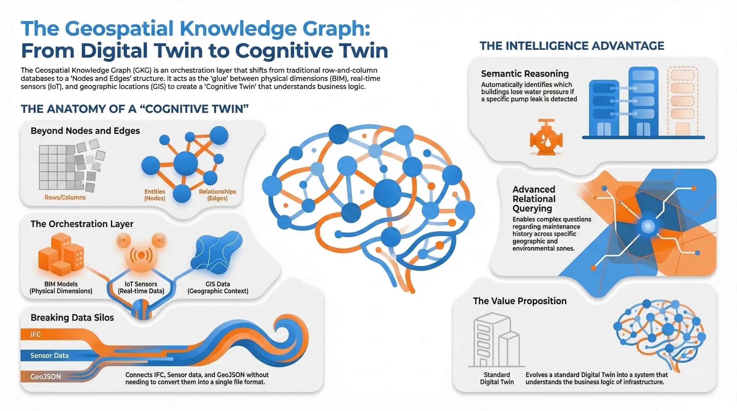
This is where a new concept is beginning to emerge in spatial intelligence: the Geospatial Knowledge Graph (GKG) .
Rather than treating geospatial information as separate datasets, a GKG organizes information as a network of connected entities , where data points become nodes and their relationships become edges in a graph structure.
This shift moves geospatial technology from data storage to data reasoning .
The Deeper Question: When Machines Interpret Geography
The rise of Geospatial Knowledge Graphs introduces an important philosophical question.
For centuries, geography has been interpreted by human intelligence. Planners, engineers, and policymakers analyze maps, study patterns, and draw conclusions.
But what happens when machines begin to interpret those relationships?
A Knowledge Graph allows systems to understand how different entities interact. A pump in a water network is no longer just a point on a map, it becomes a node connected to maintenance records, sensor readings, geographic catchments, and infrastructure models.
This means the system can reason.
If a sensor detects abnormal flow, the system can trace the network relationships and infer downstream impacts, identifying affected buildings, neighborhoods, or industrial facilities.
In other words, spatial intelligence is no longer just about visualizing geography .
It becomes about interpreting the logic of geography .
The philosophical implication is profound:
Geography itself begins to function as a decision system .
Spatial Intelligence Perspective
From a geospatial perspective, the Knowledge Graph represents a major shift in how spatial systems are designed.
Traditional geospatial databases store data in rows and columns , often separated across multiple systems, GIS databases, BIM repositories, IoT platforms, and asset management systems.
This fragmentation creates silos.
Engineers may view infrastructure in BIM systems.
Operations teams monitor sensors in IoT dashboards.
Urban planners analyze geographic layers in GIS platforms.
But the relationships between these systems often remain invisible.
A Geospatial Knowledge Graph acts as the connective intelligence layer across these domains.
It allows organizations to ask questions that traditional spatial systems struggle to answer:
Which infrastructure assets are exposed to environmental risk zones?
Which buildings depend on a specific energy substation?
Which transport routes influence supply chain resilience?
Because the data is structured around relationships rather than files , spatial reasoning becomes far more powerful.
Geography stops being a static layer in a database.
It becomes a dynamic network of interconnected systems .
Real-World Implication
Imagine a large metropolitan water utility managing thousands of infrastructure assets.
In a traditional GIS system, the utility might monitor:
Pump locations
Pipeline networks
Maintenance records
Sensor readings
Each dataset exists in its own system.
Now consider the same network managed through a Geospatial Knowledge Graph .
A single infrastructure component, a pump, can be connected to multiple systems:
A BIM model describing its physical characteristics
An IoT sensor reporting real-time flow data
A maintenance history linked to technicians and service intervals
A geographic catchment area showing downstream dependencies
If the pump fails, the system does not simply trigger an alert.
Instead, it reasons through the network:
Which pipelines will lose pressure?
Which buildings will be affected?
Which emergency response teams should be alerted?
The system understands not just the location of infrastructure, but its relationships and consequences .
This is where geospatial intelligence begins to transition from monitoring systems to decision-support systems .
Insight: The GeoThinking Perspective
The emergence of Geospatial Knowledge Graphs signals a fundamental shift in digital infrastructure.
For decades, organizations have invested in collecting spatial data. Satellites, drones, sensors, and mapping systems have generated enormous volumes of geographic information.
But data alone does not produce insight.
The real value emerges when systems understand how pieces of information relate to each other .
This is why the future of spatial intelligence may not depend solely on better sensors or more accurate maps.
It may depend on our ability to build relationship-aware spatial systems .
In this sense, the Geospatial Knowledge Graph becomes the orchestration layer that connects Digital Twins, IoT systems, and geospatial platforms into a unified intelligence network.
It transforms a Digital Twin from a visual model into something more powerful, a cognitive representation of infrastructure systems .
Closing Reflection
Human civilization has always depended on understanding geography.
Rivers determined trade routes.
Mountains shaped borders.
Cities emerged where networks converged.
Today, we are building digital systems capable of mapping and modeling the entire planet.
But the next challenge may not be mapping geography.
It may be teaching machines how geography itself works , how places influence systems, how infrastructure interacts with environments, and how spatial relationships shape decision-making.
In that sense, the Geospatial Knowledge Graph is not just a technology.
It is a step toward a world where spatial intelligence becomes the foundation of digital decision systems .