Most infrastructure failures are not caused by lack of funding.
They happen because the wrong assets are fixed first .
When budgets are limited and systems are complex, prioritization becomes more important than execution speed. Yet many infrastructure decisions still rely on age-based lists or reactive complaints.
The real decision behind infrastructure planning
Governments, utilities, and operators constantly face hard questions:
Which assets need attention now?
Where will failure cause the highest impact?
Which upgrades deliver the most value per rupee spent?
These are prioritization decisions, not engineering tasks. Treating all assets equally often leads to spreading resources thin and missing critical risks.
Why location intelligence changes prioritization
Infrastructure assets do not operate in isolation.
Their importance depends on where they are located and who or what they serve .
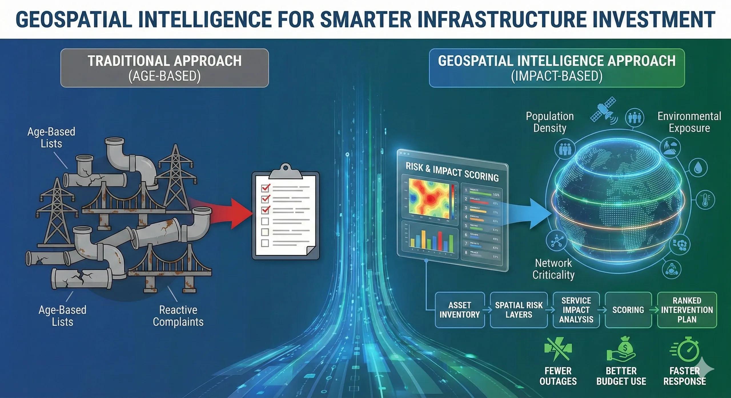
Geospatial intelligence introduces context by linking assets to:
Population density and service demand
Environmental and climate exposure
Network criticality and dependencies
Accessibility for maintenance and response
This transforms prioritization from guesswork into evidence-based ranking.
From data to decision: the prioritization flow
A geospatial prioritization workflow typically follows:
Asset inventory → spatial risk layers → service impact analysis → scoring → ranked intervention plan
Instead of asking “Which asset is oldest?” , teams ask:
“Which asset failure would hurt the most?”
That shift changes outcomes.
A practical scenario
Consider a city managing its water distribution network.
Traditional planning flags pipes based on age. Spatial analysis, however, reveals:
Certain segments serve hospitals and dense residential zones
Some lie in high soil-corrosion areas
Others are located in zones with repeated flood stress
The upgrade plan changes. Investment focuses on impact , not just condition, reducing service disruptions and emergency repairs.
Business and operational impact
When infrastructure prioritization is guided by geospatial intelligence, organizations typically see:
Fewer unplanned outages
Better use of maintenance budgets
Faster response to critical failures
Improved public trust and service reliability
The value lies in preventing high-impact failures , not reacting to them.
Where prioritization usually breaks down
Common issues include:
Treating asset lists as flat inventories
Ignoring spatial dependencies
Planning upgrades without service-impact context
Reactive funding driven by incidents rather than insight
These gaps often surface only after failures occur.
Scaling prioritization into an ongoing system
Leading organizations move beyond annual planning cycles.
They build dynamic prioritization frameworks where geospatial intelligence continuously updates risk and impact scores. This approach integrates naturally with BIM models, IoT condition data, and digital twins, keeping priorities aligned with real-world change.
The monetization bridge
As infrastructure portfolios grow, manual prioritization becomes unsustainable. Organizations increasingly look for structured advisory support and decision platforms that can continuously evaluate risk, impact, and value across assets, turning prioritization into a repeatable decision process rather than an annual debate.
Looking ahead
With real-time sensor feeds, climate projections, and AI-driven analytics, infrastructure prioritization is moving from periodic reviews to continuous decision-making . The goal is not to fix everything, but to always fix the right thing next.
Closing insight
Infrastructure resilience is not built by repairing more assets.
It is built by repairing the right assets first .