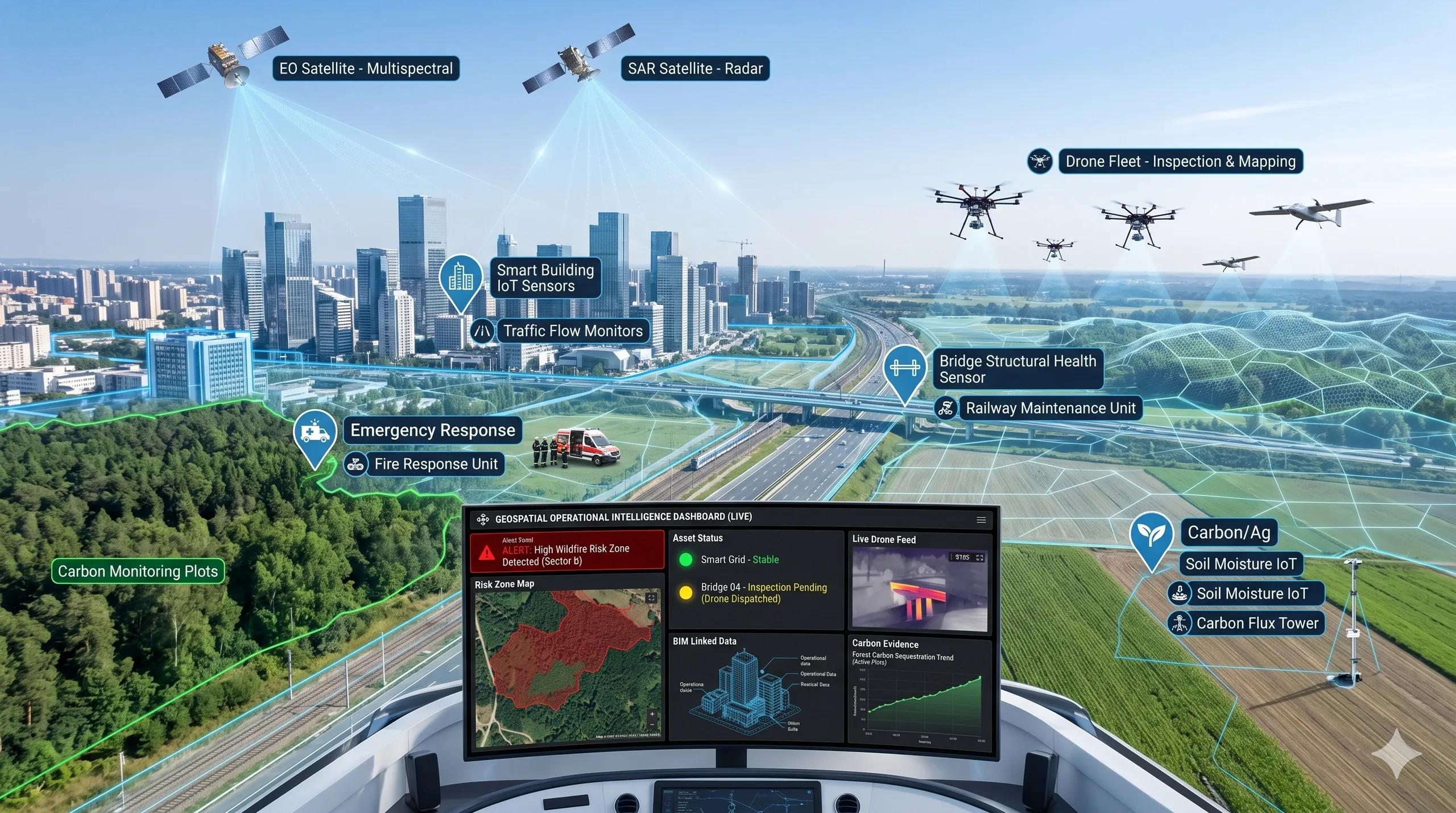
For many years, remote sensing was treated as an observation tool.
It helped us see what was happening on the ground.
It helped us map land use, monitor forests, track urban growth, assess crops, inspect infrastructure, and understand environmental change.
That role remains important.
But the next phase of geospatial intelligence is different.
The real shift is not from 2D maps to 3D models.
It is from passive observation to live decision support.
This is where geospatial technology is becoming operational infrastructure.
Not just a layer in a dashboard.
Not just an input for planning.
Not just a report generated after the event.
It is becoming part of how governments, utilities, defence agencies, infrastructure operators, insurers, logistics companies, and climate teams respond to live conditions.
The map is no longer the end product.
The decision is.
Wildfires show the direction clearly
A strong example is emerging from wildfire response.
When a fire starts, the value of spatial intelligence is not in producing a beautiful burn-area map after the damage is done. The real value is in detecting the fire early, understanding its location, estimating its intensity, and moving that intelligence into the hands of emergency responders quickly.
This is where satellite-first emergency response becomes important.
Thermal satellites, AI-based fire detection, UAV validation, weather intelligence, ground sensors, and command dashboards can work together as a live response chain.
The question is no longer:
“Can we monitor the fire?”
The question is:
“How fast can we convert detection into action?”
That is a very different standard.
In an operational environment, a few minutes can matter. A small fire can become a regional disaster. A delayed alert can increase response cost, risk to lives, and damage to assets.
This is why geospatial intelligence must move closer to the response layer.
Remote sensing alone is not enough.
A dashboard alone is not enough.
A model alone is not enough.
The real value comes when satellite signals, field validation, UAV inputs, IoT data, and command workflows are connected into one decision system.
Drones are also moving beyond survey
The same shift is happening with UAVs.
For a long time, drones were positioned mainly as data capture tools. They were used for aerial surveys, progress monitoring, stockpile measurement, inspection imagery, and mapping.
That market is still valid.
But the stronger opportunity is now moving beyond capture.
In defence, drones are already becoming part of autonomy, surveillance, tactical decision-making, and rapid response. In civil markets, the lesson is equally relevant.
The future of UAVs is not only in flying missions.
It is in converting drone outputs into inspection evidence, asset change detection, compliance records, risk alerts, and operational decisions.
For example, in infrastructure, a drone survey should not end with a folder of images.
It should answer questions such as:
Which asset has changed?
Which defect is critical?
Which location needs field validation?
Which maintenance action should be prioritized?
Which issue has regulatory or safety implications?
That is the difference between drone data and drone intelligence.
The same logic applies to highways, transmission lines, rail corridors, industrial plants, mines, ports, warehouses, agriculture, and smart cities.
The operator does not need more raw data.
The operator needs confidence, context, and a clear next step.
Digital twins are entering emergency governance
This is also why digital twins are becoming important in disaster management.
A 3D model of a city is useful. But a 3D model that can simulate floods, fires, crowd movement, evacuation routes, road closures, emergency access, and asset vulnerability is far more valuable.
This distinction matters.
Digital twins are often misunderstood as visual replicas. But the best digital twin use case is not visualization.
It is emergency readiness.
A city digital twin should help leaders test risk before it hits the ground.
What happens if a flood blocks this road?
What happens if a fire breaks out in a dense market zone?
Which hospitals remain accessible?
Which low-lying areas need early alerts?
Where should response teams be positioned?
Which assets become critical under stress?
These are operational questions.
They cannot be answered by static maps alone. They require spatial context, real-time data, simulation logic, asset intelligence, and governance workflows.
This is where the digital twin becomes more than a model.
It becomes a decision environment.
BIM is becoming the base layer for AI-ready assets
The same transition is taking place inside buildings, campuses, industrial facilities, warehouses, and utilities.
BIM has traditionally served design and construction workflows. But its next role is much larger.
BIM can become the base layer for AI-ready assets.
For that to happen, BIM cannot remain locked inside project delivery files. It must connect with GIS, IoT, CAFM, ERP, maintenance systems, energy systems, safety workflows, and operational dashboards.
A building model becomes more valuable when it can support questions like:
Which equipment is due for maintenance?
Which floor has abnormal energy consumption?
Which asset has no operational data?
Which zone has repeated complaints?
Which system is vulnerable during an emergency?
Which information is missing for automation?
This is why a BIM-to-operational-twin readiness audit is becoming necessary.
Many organizations already have BIM data. Many also have sensors, facility systems, spreadsheets, maintenance logs, and enterprise platforms.
But they do not have a connected operational layer.
The opportunity is not to rebuild everything.
The opportunity is to assess what exists, identify data gaps, connect key systems, and create a practical path from asset visibility to decision intelligence.
Carbon MRV needs hybrid evidence
Carbon markets and sustainability reporting are another example.
Satellite data is powerful. It can provide scale, consistency, and repeatable observation. But for credible MRV, satellite data alone is often not enough.
Agricultural MRV especially needs hybrid evidence.
A practical MRV stack should combine satellite baselines, UAV evidence, field measurements, soil data, crop records, farmer inputs, validation protocols, and transparent reporting dashboards.
This is not just a technical issue.
It is a trust issue.
Carbon claims must be defensible. They must be auditable. They must connect remote observation with ground reality.
That is where geospatial intelligence can play a central role.
Not as a decorative map in a sustainability report, but as the evidence framework behind the claim.
The future of MRV will belong to organizations that can combine scale with verification.
Satellite gives reach.
UAVs give detail.
Field data gives credibility.
Dashboards give traceability.
Governance gives trust.
Capital is moving toward operational intelligence
The investment signals are also clear.
Defence technology, SAR satellite intelligence, autonomous systems, drones, maritime monitoring, and AI-enabled situational awareness are attracting serious capital.
This matters because markets usually fund where operational urgency is high.
Defence, disaster response, climate risk, insurance, maritime security, border monitoring, infrastructure resilience, and emergency governance all share one common need:
They cannot wait for slow analysis cycles.
They need live intelligence.
This is why SAR, thermal sensing, EO data, UAVs, edge AI, IoT, digital twins, and geospatial platforms are converging.
The future will not be defined by one sensor or one platform.
It will be defined by the ability to orchestrate multiple signals into trusted decisions.
What this means for geospatial companies
For geospatial businesses, this creates a clear strategic shift.
The market is moving away from “we provide maps” or “we provide data.”
The stronger positioning is:
We help organizations respond faster, validate risk better, and act with confidence.
This requires a different kind of offering.
A disaster response intelligence stack.
A BIM-to-operational-twin readiness audit.
A hybrid carbon MRV evidence framework.
A UAV-based asset change detection workflow.
A SAR-enabled risk intelligence dashboard.
A city emergency readiness twin.
These are not just technology products.
They are decision-support systems.
And that is where the next value layer sits.
My perspective
Geospatial intelligence has always helped us understand the world.
But now it must help us operate the world.
That means moving from maps to models, from models to workflows, and from workflows to decisions.
The organizations that win will not be the ones that collect the most spatial data.
They will be the ones that connect spatial data to action.
Because the real opportunity is not observation.
It is response.
And in a world facing climate volatility, infrastructure pressure, defence uncertainty, urban complexity, and sustainability accountability, response is becoming the new measure of geospatial value.