Climate change is no longer a projection.
It is an operational variable.
Heatwaves affect productivity.
Floods disrupt logistics.
Water stress reshapes agriculture.
The real risk is not climate change itself.
It is planning as if conditions will remain stable.
The real decision behind climate adaptation
Across infrastructure, utilities, cities, agriculture, and industry, leaders face difficult questions:
Which assets are exposed to future climate risk?
Where should resilience investments be prioritized?
Which regions are becoming unsuitable for long-term expansion?
How do we balance growth with environmental stability?
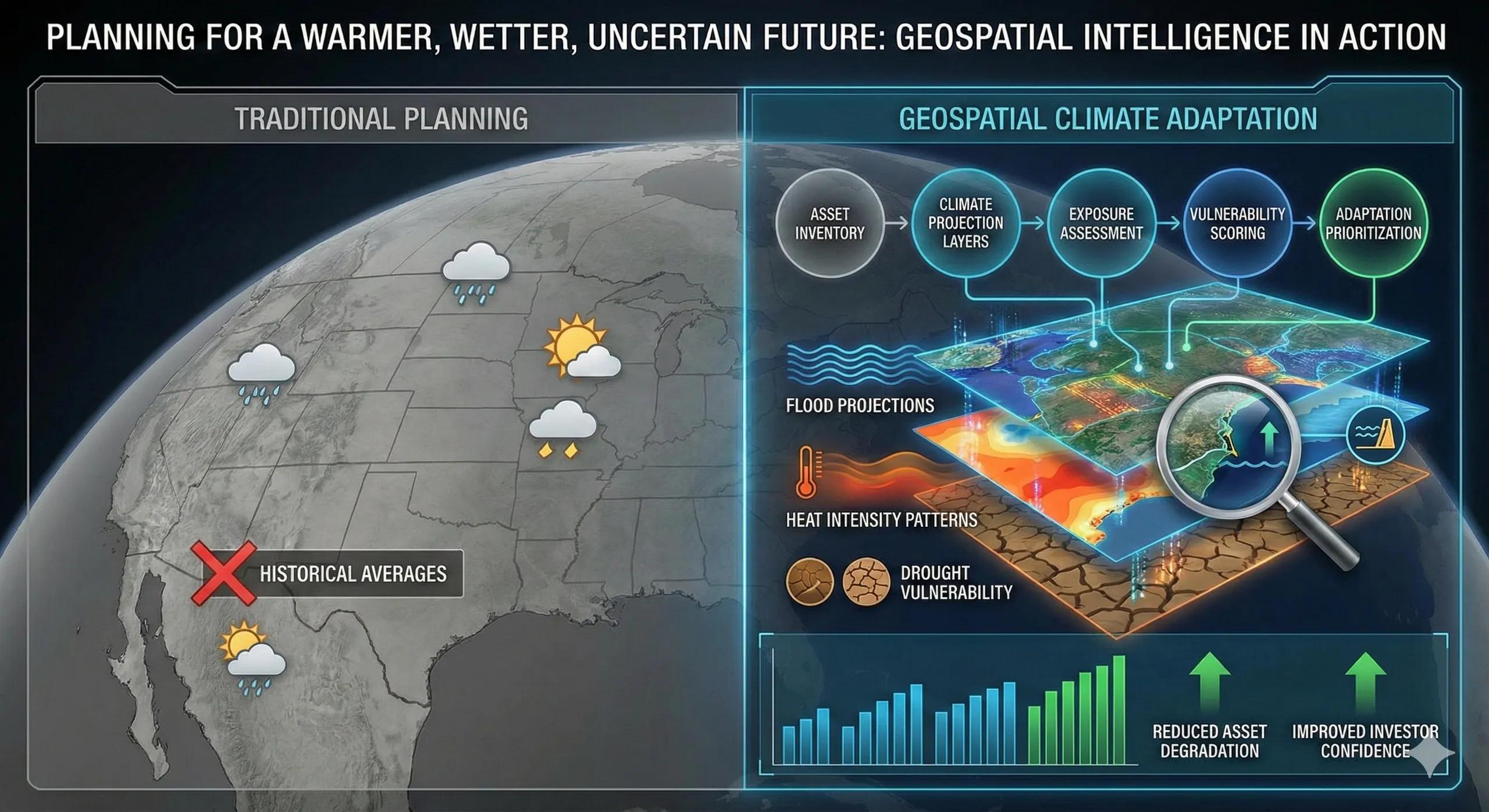
Traditional planning often relies on historical averages.
Climate volatility makes historical patterns unreliable.
The decision challenge is no longer “what happened before?”
It is “what is likely to change next?”
Why location intelligence is central to adaptation
Climate impacts are uneven.
Some zones face intensified flooding.
Others face rising heat stress.
Some regions may experience water scarcity or land degradation.
Geospatial intelligence enables organizations to overlay:
Flood projections
Heat intensity patterns
Drought vulnerability
Sea-level rise zones
Storm frequency corridors
Soil and land stability data
Instead of generalized climate awareness, leaders see specific exposure tied to specific assets and regions .
This moves adaptation from theory to action.
From data to decision: the climate resilience flow
A structured climate adaptation framework typically follows:
Asset/region inventory → climate projection layers → exposure assessment → vulnerability scoring → adaptation prioritization
The result is not just a sustainability report.
It becomes a decision tool guiding:
Reinforcement investments
Relocation planning
Insurance strategy
Regulatory compliance
Long-term capital allocation
Climate becomes a design constraint, not a surprise event.
A practical scenario
Consider a regional infrastructure operator managing transport corridors.
Historical flood records show occasional disruptions. But spatial climate projections reveal:
Flood plains expanding beyond current assumptions
Increased extreme rainfall frequency
Heat stress zones affecting pavement durability
Instead of reacting after repeated damage, the operator prioritizes:
Elevated reinforcement in high-risk corridors
Drainage redesign
Alternative routing strategies
The cost remains significant, but the disruption risk reduces dramatically.
Adaptation becomes proactive rather than reactive.
Business and operational impact
Organizations integrating geospatial climate intelligence often achieve:
Reduced long-term asset degradation
Lower emergency repair costs
Stronger compliance with environmental regulations
Improved investor confidence
Enhanced ESG performance transparency
Resilience becomes measurable.
Where climate planning often falls short
Common gaps include:
Treating sustainability separately from infrastructure planning
Using national averages without local granularity
Ignoring compound risks (e.g., heat + power demand + water stress)
Conducting climate assessments only for compliance
Without spatial context, climate strategy remains generic.
With spatial context, it becomes actionable.
Scaling adaptation into ongoing systems
Leading organizations embed climate layers into their planning dashboards and digital twins, allowing:
Continuous exposure monitoring
Scenario simulation
Risk-based prioritization
Capital planning aligned with resilience
This integration ensures climate adaptation is not a one-time study, but a continuous decision variable.
The monetization bridge
As regulatory scrutiny increases and investors demand climate disclosure, organizations increasingly seek structured advisory approaches and scalable spatial decision systems that integrate climate projections directly into planning workflows, turning adaptation from reporting into operational strategy.
Looking ahead
With AI-driven climate modeling, real-time environmental sensing, and predictive simulations, adaptation planning will shift from static reports to dynamic forecasting.
The competitive advantage will belong to those who plan for the next 20 years, not just the next quarter.
Closing insight
Climate uncertainty cannot be eliminated.
But its geographic footprint can be mapped.
And what can be mapped can be managed.