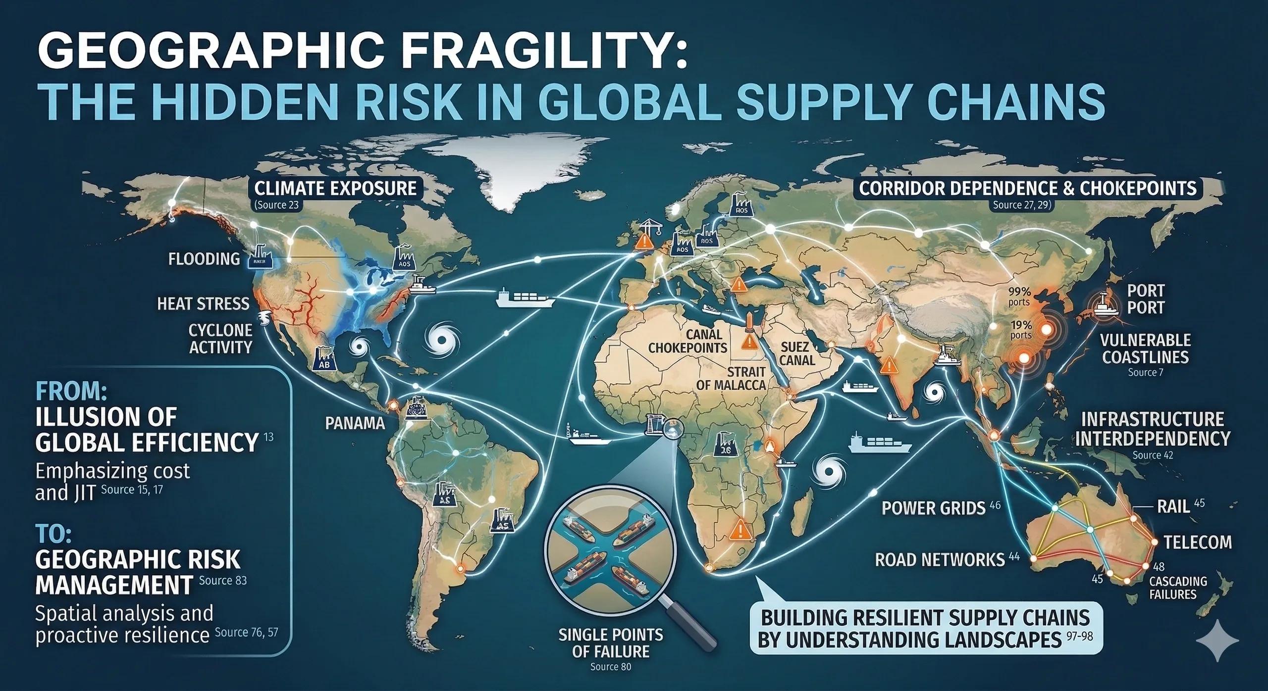
Supply Chains Are Not Just Networks, They Are Landscapes
Global supply chains are often described as networks of suppliers, factories, and logistics partners .
But beneath every supply chain diagram lies something more fundamental:
Geography.
Factories sit in specific regions.
Ports operate in vulnerable coastlines.
Shipping routes pass through chokepoints.
Transport corridors cross fragile terrain.
Supply chains are not just economic systems.
They are geographic systems .
And when geography becomes fragile, supply chains become fragile.
The Illusion of Global Efficiency
For decades, supply chain strategy prioritized:
cost optimization
production efficiency
just-in-time delivery
centralized manufacturing hubs
These strategies created highly efficient systems.
But they also created geographic concentration .
A single flood, port shutdown, drought, or geopolitical disruption can now ripple across global production networks.
Efficiency improved.
Resilience often declined.
Geography Reveals Hidden Vulnerabilities
Many supply chain risks remain invisible when viewed only through operational metrics.
Spatial analysis reveals vulnerabilities such as:
1️⃣ Corridor Dependence
Critical logistics routes passing through a limited number of transport corridors.
Example risks:
canal chokepoints
mountain passes
major shipping lanes
2️⃣ Port Concentration
A significant percentage of global trade moves through a small number of ports.
Disruption to one major port can impact entire industries.
3️⃣ Climate Exposure
Manufacturing hubs located in regions exposed to:
flooding
heat stress
water scarcity
cyclone activity
Climate volatility increasingly disrupts production schedules.
4️⃣ Infrastructure Interdependency
Supply chains depend on layered infrastructure:
roads
rail networks
power grids
telecommunications
Failure in one system cascades across others.
A Realistic Scenario
Consider a manufacturing company sourcing components from a coastal industrial cluster.
Financial indicators appear strong.
But spatial analysis reveals:
factories located in flood-prone zones
logistics dependent on a single port
critical transport routes crossing landslide-prone terrain
Operational metrics alone would not reveal this fragility.
Geospatial analysis exposes the systemic risk.
Why Supply Chain Fragility Is Increasing
Several global trends are amplifying geographic vulnerability.
Climate Volatility
Extreme weather events increasingly disrupt transport corridors and production zones.
Urban Concentration
Industrial hubs cluster around major cities and ports, increasing exposure.
Infrastructure Aging
Many global logistics networks operate on aging infrastructure.
Geopolitical Tensions
Trade routes and strategic corridors face growing geopolitical pressures.
These forces make geographic risk a central strategic concern.
The Rise of Spatially Aware Supply Chains
Forward-looking organizations are beginning to integrate spatial intelligence into supply chain strategy.
Key capabilities include:
geographic risk mapping of suppliers
transport corridor vulnerability analysis
climate scenario modeling for logistics routes
regional diversification planning
This allows companies to shift from reactive disruption management to proactive resilience planning.
What Leadership Should Be Asking
Executives overseeing supply chains should increasingly ask spatial questions:
Where are our suppliers geographically concentrated?
Which logistics routes represent single points of failure?
How exposed are our operations to climate volatility?
Are we over-dependent on fragile transport corridors?
These questions transform supply chain management into geographic risk management .
The Monetization Bridge
As global supply chains face increasing volatility, organizations are adopting spatial intelligence platforms and digital supply chain models that integrate geographic exposure, climate risk layers, logistics networks, and supplier locations into unified decision environments. These systems allow leadership to identify vulnerabilities early and redesign supply networks for resilience and continuity.
Looking Ahead
In the coming decade, supply chains will be judged not only by efficiency but by geographic resilience .
Organizations that understand spatial exposure will:
diversify supplier regions
redesign logistics corridors
anticipate disruption earlier
maintain operational continuity
Those that ignore geography will continue reacting to crises after they occur.
Closing Insight
Supply chains do not operate in spreadsheets.
They operate across landscapes.
Understanding those landscapes is the first step toward building resilient global systems.