India’s space story is entering a new phase.
For many years, the conversation around space was largely about launch capability, satellites, national missions, and scientific achievement. That foundation remains important. But the next layer of value will come from something more practical:
How do we convert space-based data into decisions on the ground?
This is where India’s next geospatial stack becomes important.
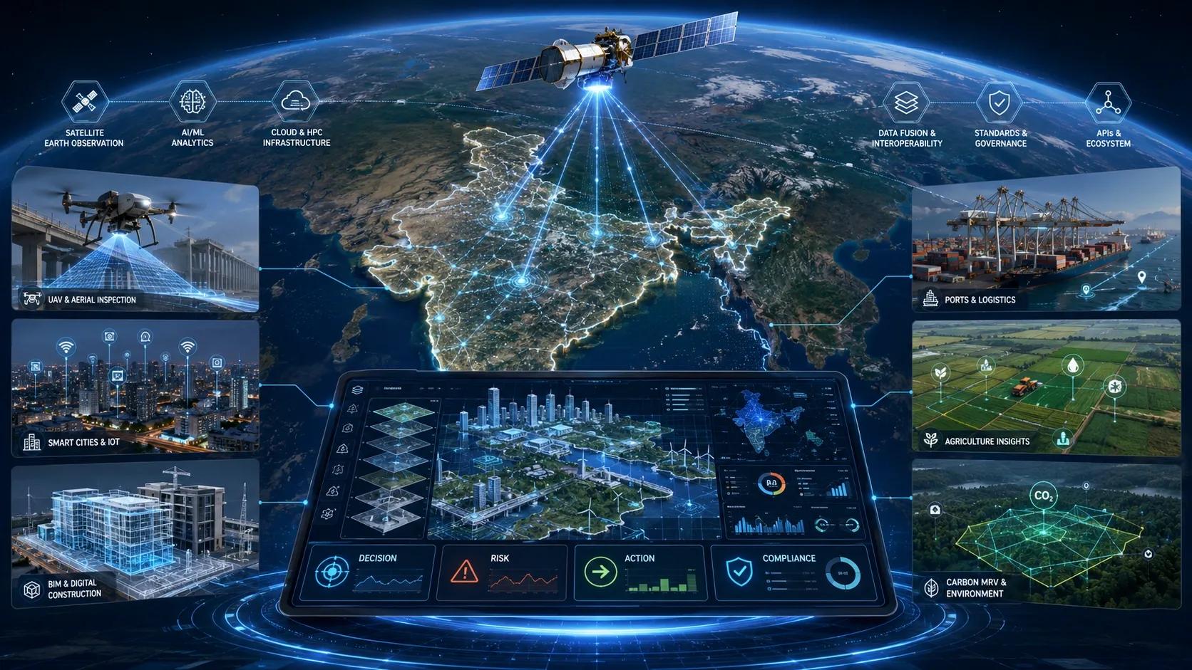
The opportunity is no longer only about launching satellites, capturing imagery, or building maps. The real opportunity is to connect space access, Earth observation, AI models, digital twins, UAVs, IoT, BIM, and field workflows into decision-ready systems.
In simple terms, India does not only need more spatial data.
India needs spatial intelligence that can act.
The Stack Is Expanding
A modern geospatial stack is no longer a single technology layer.
It now begins with satellites, drones, sensors, and field teams. It moves through cloud platforms, AI models, geospatial databases, BIM models, IoT networks, and simulation engines. It finally reaches operations through dashboards, alerts, workflows, compliance reports, and decisions.
This full chain matters because most organizations do not struggle with a lack of data.
They struggle with disconnected data.
A satellite image may show land-use change.
A drone survey may confirm site-level evidence.
An IoT sensor may show live asset behaviour.
A BIM model may describe built infrastructure.
A GIS layer may provide location context.
An AI model may detect risk or change.
A digital twin may simulate outcomes.
But unless these layers are connected, they remain separate pieces of intelligence.
The next market opportunity is integration.
Space Access Is Only the Starting Point
Private participation in India’s space sector is an important milestone. It shows that the launch ecosystem is opening up, capital is flowing, and space infrastructure is moving beyond a purely government-led model.
But launch capability is only the beginning.
The larger question is: what happens after the data is generated?
A satellite does not create business value by itself.
A constellation does not solve an infrastructure problem by itself.
An image does not help a city unless it is interpreted, validated, and linked to action.
The real commercial value emerges when space data becomes part of operational workflows.
For example:
A satellite detects flooding risk.
A drone validates the ground condition.
IoT sensors monitor water levels.
A GIS platform maps affected assets.
A digital twin simulates response scenarios.
A dashboard guides field teams.
A report supports governance and compliance.
That is the shift from Earth observation to Earth intelligence.
India Needs Localized Geospatial Intelligence
Global AI models are powerful, but India’s geography, climate, land-use patterns, infrastructure density, agricultural diversity, and urban complexity demand localized intelligence.
A model trained for generic global interpretation may not fully understand Indian field boundaries, informal settlements, monsoon behaviour, irrigation patterns, construction density, rural roads, encroachments, mixed land use, or infrastructure conditions.
This is why India-focused Earth observation models matter.
They can improve how we monitor agriculture, climate risk, urban growth, infrastructure corridors, water bodies, forests, disaster exposure, and carbon projects.
But again, the model itself is not the final product.
The product is the decision layer built on top of it.
An agriculture department does not need only a vegetation index. It needs crop stress alerts, village-level prioritization, field validation plans, yield-risk reports, and advisory workflows.
A port does not need only a 3D model. It needs congestion intelligence, asset tracking, predictive maintenance, emissions monitoring, and scenario planning.
A city does not need only a digital twin. It needs flood preparedness, traffic response, asset governance, encroachment monitoring, and emergency coordination.
A carbon project does not need only satellite analytics. It needs boundary mapping, baseline evidence, change detection, field validation, uncertainty handling, and audit-ready MRV.
This is where geospatial companies must move up the value chain.
Digital Twins Are Becoming Operational Layers
The phrase “digital twin” is often misunderstood.
Many still treat it as a 3D visualization exercise. But the more valuable version of a digital twin is not just a model that looks like the real world.
It is a system that understands the real world.
An operational digital twin connects assets, location, time, condition, risk, behaviour, and decisions.
For India, the most practical digital twin opportunities are not abstract city-scale demonstrations. They are focused operational pilots:
A smart port digital twin.
A flood-risk zone digital twin.
A road corridor digital twin.
A warehouse or logistics twin.
A utility network twin.
An industrial campus twin.
A carbon MRV twin.
A construction progress twin.
Each of these use cases has a clear business question:
What changed?
What is at risk?
What needs attention?
What should be inspected?
What should be repaired?
What can be optimized?
What evidence is available?
What decision should be taken?
This is where the next layer of spatial intelligence will be judged.
Not by visual quality alone.
But by decision quality.
UAVs and IoT Complete the Ground Truth Layer
Satellites provide scale.
Drones provide detail.
IoT provides continuity.
Field teams provide verification.
Together, they create the evidence chain.
This evidence chain is critical because AI-based spatial decisions must be trusted. If an AI model flags illegal construction, infrastructure damage, vegetation stress, asset movement, or carbon loss, the system must show where the evidence came from and how reliable it is.
That means the future geospatial stack must include:
Source traceability.
Timestamped observations.
Geo-tagged field validation.
Sensor records.
Drone imagery.
Satellite history.
Change logs.
Confidence scores.
Audit trails.
This is especially important in sectors like infrastructure, utilities, smart cities, insurance, carbon markets, disaster response, and public governance.
A decision-ready geospatial platform must not only answer “what is happening?”
It must also answer “how do we know?”
The Founder Opportunity
For BSMA Enterprises and Dhineu , this shift creates a clear strategic direction.
The market does not need another isolated GIS service, drone survey, BIM model, IoT dashboard, or AI demo.
The market needs integrated spatial decision systems.
This creates opportunities around:
EO-to-workflow intelligence.
Smart infrastructure monitoring.
BIM-GIS-IoT convergence.
UAV-based inspection evidence.
Digital MRV for carbon and ESG.
Smart port and logistics twins.
City-zone digital twin pilots.
AI-ready asset data layers.
Geospatial due diligence for data centers and infrastructure.
The strongest positioning is not “we provide geospatial services.”
It is:
We help organizations convert physical-world data into trusted operational decisions.
That message is simple, practical, and business-facing.
The Next Geospatial Stack
India’s next geospatial stack will not be built by space companies alone.
It will need collaboration between satellite operators, drone companies, GIS experts, BIM teams, AI engineers, IoT integrators, cloud platforms, infrastructure owners, government agencies, and domain specialists.
The winners will be the teams that can connect these layers into business workflows.
Because the end user does not want to manage five disconnected technologies.
They want answers.
Is this asset safe?
Is this project delayed?
Is this land changing?
Is this crop at risk?
Is this corridor encroached?
Is this port congested?
Is this carbon claim defensible?
Is this city prepared for flooding?
Is this infrastructure ready for AI-scale growth?
That is the real future of geospatial intelligence.
From space access to spatial decisions.
From Earth observation to Earth intelligence.
From digital maps to operational evidence.
From isolated platforms to connected decision systems.
This is India’s next geospatial stack.
And the organizations that build it well will not only visualize the physical world.
They will help govern, protect, optimize, and transform it.
At BSMA Enterprises , we help organizations move from spatial data collection to decision-ready geospatial intelligence by combining GIS, BIM, UAVs, IoT, AI, digital twins, and MRV workflows into practical operational systems.
The next advantage will not come from seeing more.
It will come from deciding better.