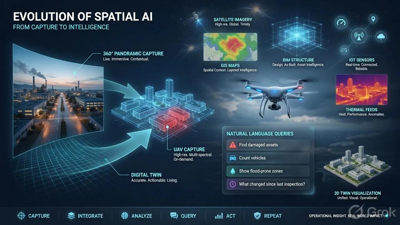
For years, spatial intelligence has been built around one basic question:
Can we capture the physical world accurately enough to understand it digitally?
The first answer came from satellite imagery, aerial mapping, LiDAR, mobile mapping, drone surveys, BIM models, and field inspections.
Each of these capture methods solved part of the problem.
Satellites gave us scale.
Drones gave us flexibility.
LiDAR gave us geometry.
BIM gave us asset structure.
IoT gave us live signals.
Mobile mapping gave us street-level context.
But the next phase of spatial AI is not only about capturing more data.
It is about making every capture layer understandable, queryable, and operational.
That is why panoramic twins and UAV-language intelligence matter.
They point to a shift from “viewing the world” to “asking the world questions.”
360° imagery is becoming a practical gateway into digital twins
Digital twins have often been associated with expensive capture workflows.
High-density LiDAR scans, detailed BIM models, complex sensor integrations, and large engineering teams are powerful, but they are not always practical for every road corridor, campus, warehouse, industrial site, or municipal asset.
This is where panoramic capture becomes important.
A 360° camera mounted on a vehicle, helmet, tripod, or inspection device can collect rich visual context at a much lower cost than traditional survey-heavy methods.
Earlier, this was mainly useful for virtual walkthroughs or visual documentation.
Now, AI is changing its role.
Panoramic reconstruction methods are beginning to convert 360° imagery into structured 3D environments. With approaches like panoramic 3D Gaussian Splatting, geometry-aware generation, inpainting, outpainting, and scene editing, panoramic imagery is no longer just a visual record.
It can become a digital twin input.
That matters for cities, roads, campuses, factories, utilities, airports, warehouses, and construction sites.
Instead of asking every organization to start with a full-scale 3D survey, we can begin with a lower-cost capture layer and progressively enrich it with GIS, BIM, IoT, asset data, and AI models.
This makes digital twins more accessible.
And accessibility is important because many organizations do not fail at digital twins because they lack ambition.
They fail because the first step is too heavy, too costly, or too disconnected from daily operations.
The capture layer is becoming multimodal
The next capture layer for spatial AI will not be one sensor.
It will be a combination of many sensors:
Satellite imagery for regional monitoring.
Drones for local inspection.
360° cameras for immersive site capture.
Thermal cameras for heat, leakage, night visibility, and asset stress.
LiDAR for precise geometry.
IoT sensors for live condition data.
Legacy DEMs and old records for terrain context.
BIM and GIS for asset identity and location intelligence.
The important point is not that we have more data.
The important point is that these sources are beginning to work together.
For example, a road corridor digital twin may use satellite data for land-use change, drone imagery for inspection, 360° capture for visual context, LiDAR for geometry, IoT for traffic or environmental signals, and AI for defect detection.
A warehouse twin may use panoramic capture for layout context, RGB-thermal cameras for monitoring, UWB or BLE for asset movement, and AI models for safety or productivity insights.
A wildfire-risk model may combine legacy terrain data, fresh imagery, vegetation conditions, and simulation.
This is the real direction of spatial AI.
Not one perfect model.
A living, layered view of reality.
UAV intelligence is moving from image viewing to language grounding
Drone imagery has become common across infrastructure, agriculture, mining, disaster response, utilities, and security.
But in many projects, drone data is still handled like a visual archive.
Capture images.
Upload them.
Annotate them.
Generate a report.
Share a dashboard.
That workflow is useful, but it is still slow.
The next step is different.
Operators should be able to ask:
“Find all damaged roof sections.”
“Show me vehicles near the restricted zone.”
“Count the solar panels with visible defects.”
“Where is waterlogging visible?”
“Which assets changed since the last flight?”
“Highlight the area where vegetation is encroaching on the power line.”
“Explain what looks abnormal in this drone image.”
This is UAV-language intelligence.
It combines visual understanding with natural-language grounding.
Instead of forcing users to interpret every image manually, the system begins to understand the image in relation to a question.
This is especially important for non-GIS users.
A field engineer, emergency responder, project manager, municipal officer, or facility head does not always want to open layers, toggle tools, or inspect hundreds of images.
They want answers.
This does not remove the expert.
It helps the expert move faster.
The drone becomes not only a flying camera, but a queryable inspection assistant.
Digital twins need capture layers that support change
Many digital twins are impressive on day one.
The challenge begins on day thirty, day ninety, or year two.
A road gets repaired.
A utility trench is reopened.
A warehouse rack is moved.
A factory line is reconfigured.
A building façade is modified.
A construction site progresses.
Vegetation grows near power lines.
Water bodies shift after heavy rainfall.
If the twin does not capture change, it becomes stale.
That is why the new capture layer must support repeated, lightweight, and intelligent updates.
Panoramic capture helps here because it can document environments quickly.
Drone capture helps because it can inspect hard-to-reach areas.
Satellite imagery helps because it can monitor wide regions continuously.
Thermal and RGB sensing help because they reveal what normal imagery may miss.
AI helps because it can detect differences, flag anomalies, and connect changes to decisions.
The goal is not just to create a digital twin.
The goal is to keep it operationally current.
That is the real value.
Spatial AI must become queryable across every sensor
The most important shift is this:
Every sensor feed must become queryable.
Not just searchable by file name.
Queryable by meaning.
A user should not need to know whether the answer sits inside a satellite image, a drone photo, a panoramic scene, a thermal feed, a BIM object, an IoT stream, or a GIS layer.
The system should understand the question and retrieve the relevant spatial evidence.
For example:
“Which road sections are most exposed to flood risk and poor surface condition?”
“Which warehouse zones show congestion and temperature anomalies?”
“Which plantation areas show stress and lower suitability?”
“Which city blocks show high vulnerability and low infrastructure access?”
“Which assets need inspection before the next maintenance cycle?”
This is where spatial AI becomes useful for decisions.
The capture layer feeds the intelligence layer.
The intelligence layer supports the workflow.
The workflow leads to action.
The action feeds back into the twin.
That loop is the foundation of operational spatial intelligence.
What this means for Indian and emerging markets
This shift is particularly relevant for markets like India, the Middle East, Africa, and Southeast Asia.
Many assets in these regions are expanding fast, but their records are incomplete, outdated, or fragmented.
Cities are growing.
Roads are being upgraded.
Utilities are being relocated.
Industrial facilities are being modernized.
Climate risk is increasing.
Public agencies need better visibility.
Private operators need faster decisions.
But not every organization can begin with a high-cost, enterprise-grade digital twin program.
A practical path is needed.
Start with panoramic capture where detailed survey is too expensive.
Use UAVs where field inspection is slow or unsafe.
Add satellite intelligence where scale matters.
Bring in thermal sensing where visual data is not enough.
Connect this with GIS, BIM, IoT, and asset records.
Then make the entire system queryable through AI.
This creates a realistic entry point.
Not a digital twin as a luxury project.
A digital twin as a decision support layer.
The next competitive advantage
The next advantage in geospatial AI will not come from collecting the largest amount of data.
It will come from converting captured reality into operational answers.
Panoramic twins will reduce the cost of spatial context.
UAV-language intelligence will reduce the effort of inspection.
Dynamic 3D methods will help twins handle real-world movement.
RGB-thermal fusion will improve monitoring in difficult conditions.
Satellite and terrain models will support wider climate and infrastructure intelligence.
Together, these technologies are building the next capture layer for spatial AI.
A layer where every image, scan, sensor feed, and model becomes part of a connected decision system.
This is where the industry is heading.
From static maps to living models.
From visual dashboards to queryable environments.
From disconnected capture to operational intelligence.
The future of spatial AI will not be defined by how much of the world we can see.
It will be defined by how clearly we can ask questions of the world — and how confidently we can act on the answers.