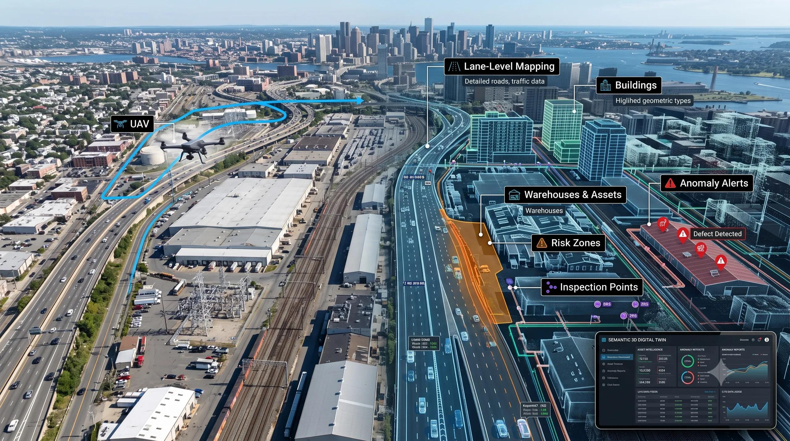
For many years, aerial imagery was treated mainly as a mapping input.
Capture the area.
Process the image.
Create the basemap.
Overlay the assets.
Use it for planning, monitoring, or reporting.
That workflow still matters. But it is no longer enough.
Aerial imagery is now entering a new phase.
It is moving from static map production to machine-readable spatial intelligence. It is becoming an input for lane-level maps, urban asset inventories, digital twins, autonomous systems, industrial inspections, and operational decision-making.
The shift is clear:
We are moving from aerial maps to semantic 3D twins .
And this change will reshape how geospatial teams, infrastructure owners, mobility operators, smart cities, factories, warehouses, and utilities use spatial data.
1. Aerial imagery is becoming a generator, not just a reference layer
Traditional aerial mapping has always helped us understand what exists on the ground.
But the next wave is different.
AI models are beginning to extract more structured intelligence directly from imagery. Roads are no longer just visible lines. They can become lane-level maps. Buildings are no longer just polygons. Their facades can become classified surfaces. Industrial environments are no longer only inspection photos. They can become anomaly reports.
This matters because a large part of spatial data creation is still manual, slow, and expensive.
Road networks need regular updates.
Smart-city corridors need asset layers.
Logistics parks need movement intelligence.
Urban planners need building-level information.
Utilities need inspection-ready asset context.
If aerial imagery can help generate these layers faster, the economics of geospatial intelligence will change.
The value will no longer come only from capturing imagery.
The value will come from converting imagery into operational structure.
2. Lane-level maps are becoming a road twin foundation
One of the most important signals is the rise of AI-assisted lane-level map generation from aerial imagery.
This is not just useful for autonomous vehicles.
It has wider relevance.
Lane-level intelligence can support road safety audits, traffic analytics, logistics route optimization, corridor planning, infrastructure maintenance, and urban mobility simulation.
For road digital twins, this is especially important.
A road twin should not stop at road centerlines, asset points, and pavement condition scores. It should understand the operational geometry of the corridor.
Where are the lanes?
Where are the turning zones?
Where are the intersections?
Where are the bottlenecks?
Where is movement likely to become unsafe or inefficient?
This is where aerial imagery starts moving from “map background” to “operational input.”
Aerial intelligence can feed mobility models, traffic systems, inspection workflows, and decision dashboards.
The road twin becomes more than a visual representation.
It becomes a spatial operating layer.
3. Cloud-robust remote sensing is becoming operational continuity
In remote sensing, cloud contamination has always been a practical challenge.
For agriculture, flood monitoring, climate intelligence, land-use change, and urban expansion analysis, missing or unclear imagery can break continuity.
And continuity matters.
A farmer advisory model cannot wait for perfect imagery.
A flood monitoring system cannot depend on occasional clean scenes.
A climate intelligence workflow cannot afford large blind spots.
An urban change detection system cannot miss critical land transformation.
That is why cloud removal is not a cosmetic enhancement.
It is an operational requirement.
When AI can improve the reliability of optical satellite imagery by using geo-context, alignment, and observation-aware correction, remote sensing becomes more dependable for real-world workflows.
This is important for India, the Middle East, Africa, and Southeast Asia, where agriculture, flood risk, infrastructure growth, and climate resilience all need more frequent and reliable monitoring.
The future of remote sensing is not only higher resolution.
It is higher operational reliability.
4. Semantic 3D twins will be searchable, not just visual
Most digital twins today are still judged by how they look.
Is the model realistic?
Is the dashboard clean?
Is the 3D view impressive?
Can users rotate, zoom, and inspect assets?
These are useful features, but they are not the end goal.
The next generation of 3D twins will be judged by what they understand.
Can the twin identify objects?
Can it understand spaces?
Can it classify risk zones?
Can it answer operational questions?
Can it connect visual geometry with asset logic?
This is where semantic 3D becomes critical.
3D Gaussian Splatting and similar techniques are making 3D reconstruction faster and more visually rich. But the real breakthrough begins when these 3D scenes become semantic.
A warehouse twin should not only show racks, aisles, pallets, docks, and equipment.
It should allow a user to ask:
“Show all blocked pathways.”
“Find damaged assets.”
“Highlight high-risk zones.”
“Where is the loading area underutilized?”
“Which objects changed since the last scan?”
That is the real shift.
The digital twin becomes searchable.
It becomes queryable.
It becomes useful for operations, not only presentations.
5. Facade intelligence can unlock a new urban asset layer
Building facades are often overlooked in geospatial workflows.
But facade-level intelligence can support many use cases.
Urban asset inventories.
Building energy studies.
Property intelligence.
Municipal planning.
Disaster risk assessment.
BIM-GIS enrichment.
Smart-city digital twins.
Infrastructure condition monitoring.
A building footprint tells us where a building is.
A facade understanding tells us more about what the building is, how it behaves, how it performs, and what risks or opportunities it may carry.
As AI improves facade segmentation across diverse global environments, cities can create richer building intelligence layers without starting from heavy manual surveys.
This has strong relevance for urban India.
Many cities need better building-level information, but traditional data creation is slow. AI-assisted facade intelligence can help create a more practical bridge between aerial imagery, street imagery, BIM models, energy analytics, and urban digital twins.
6. Industrial anomaly intelligence will reduce inspection friction
Another important shift is lightweight anomaly detection.
Factories, warehouses, utilities, pipelines, campuses, and infrastructure assets all need inspection.
But most AI inspection systems face the same barrier:
They need labeled defect data.
In many real environments, defects are rare, inconsistent, and hard to classify in advance. This makes traditional supervised AI deployment difficult.
Zero-shot and lightweight anomaly detection can reduce this friction.
Instead of waiting for large labeled datasets, organizations can begin with visual inspection intelligence that detects what appears unusual, damaged, misaligned, missing, or risky.
This can support:
Factory quality inspection.
Warehouse safety audits.
Utility asset inspection.
Road condition monitoring.
Construction progress checks.
Industrial equipment monitoring.
For operational spatial intelligence, this is a major opportunity.
The workflow becomes:
Capture image → detect anomaly → locate issue → classify risk → assign action → track resolution.
That is when visual AI becomes operational AI.
7. Edge AI and collaborative 3D perception will decide scalability
A key challenge in spatial intelligence is deployment.
It is easy to build a demo in a controlled environment.
It is harder to deploy across roads, warehouses, construction sites, ports, utilities, factories, and campuses where bandwidth, devices, robotics, sensors, and field conditions vary.
This is why edge AI matters.
Collaborative 3D occupancy, portable robot inference, and low-bandwidth perception systems will become important for real-world adoption.
The future spatial stack cannot depend only on cloud-heavy processing.
Some intelligence must move closer to the field.
Drones, robots, cameras, vehicles, and IoT devices will need to understand their environment locally, exchange limited but useful information, and support faster decisions.
For operational digital twins, this means the twin will not only receive data.
It will interact with distributed field intelligence.
8. Security will become part of the spatial twin stack
As XR, robotics, field devices, and digital twins become connected, access control becomes more important.
A 3D twin of a factory, warehouse, airport, road network, utility system, or city is not just a visualization tool.
It can contain sensitive operational information.
Who can access the model?
Who can see asset details?
Who can trigger workflows?
Who can inspect restricted areas?
Who can modify spatial records?
As spatial computing grows, authentication and role-based access will become part of the digital twin architecture.
Security cannot remain an afterthought.
The more operational the twin becomes, the more governed it must be.
The real message: spatial intelligence is becoming operational infrastructure
The geospatial industry is entering an important transition.
Aerial imagery is becoming structured intelligence.
Remote sensing is becoming more reliable.
3D scenes are becoming semantic.
Digital twins are becoming searchable.
Inspection workflows are becoming AI-assisted.
Robotics and edge devices are becoming part of the spatial stack.
XR is becoming part of operational access.
This is not just a technology upgrade.
It is a change in how organizations will understand, monitor, and manage the physical world.
The next competitive advantage will not come from having more imagery or better-looking 3D models.
It will come from the ability to convert physical reality into structured, searchable, secure, and decision-ready spatial intelligence.
That is the new AI stack for operational spatial intelligence.
And it starts with a simple shift in thinking:
Do not just map the world.
Make the world understandable, queryable, and actionable.
At BSMA, we help organizations move from static spatial data to operational intelligence by connecting geospatial data, BIM, UAVs, remote sensing, AI, digital twins, and decision workflows.
Because the future of digital twins is not prettier 3D.
It is spatial intelligence that can support real decisions.