The twin challenges of healthcare and education delivery in underserved regions remain unresolved despite decades of investment. Rural and remote communities often face long delays in accessing medical services, shortages of essential supplies, and inconsistent access to quality learning resources. In India and other developing countries, these challenges are amplified by geography, limited infrastructure, and growing demand.
Recent advances in Earth Observation (EO) and drone-based infrastructure offer a new way forward. By combining high-resolution spatial data with aerial logistics and connectivity, governments and organizations can build decentralized systems that take essential services closer to the point of need. This article explores how EO and drones can work together to reshape healthcare and education delivery at scale.
Why Decentralization Matters
Centralized systems, where hospitals, labs, and schools are concentrated in urban hubs, are efficient in dense cities but break down in rural contexts.
Healthcare: A simple blood sample may take days to reach a lab. Cold-chain dependent vaccines often spoil during transport.
Education: Schools lack reliable connectivity, making it difficult to deliver digital curricula or standardize teacher training.
Decentralization means smaller hubs, distributed networks, and technology-driven logistics, exactly where EO and drones fit.
EO for Strategic Planning
Earth Observation is not only about satellite images, it is about decision intelligence.
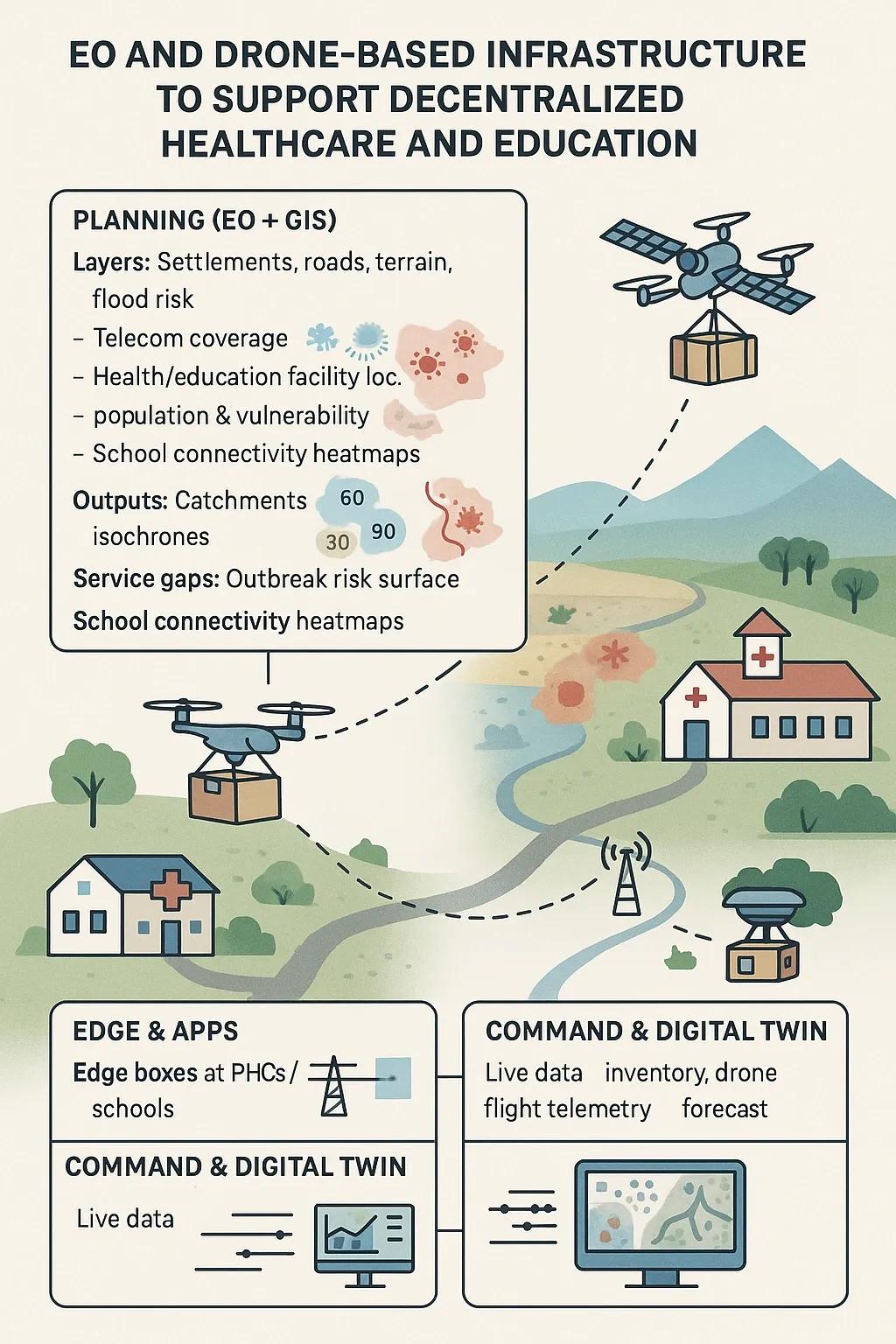
Healthcare Needs Mapping Overlay population density, road access, terrain, and seasonal flood risk. Identify which communities are outside 30, 60, or 90-minute access zones to the nearest facility. Predict disease hotspots using rainfall, vegetation, and water-body indices to anticipate malaria or cholera risk.
Education Connectivity Gap Analysis Map school locations, electricity availability, and telecom coverage. Use EO-driven models to predict where digital classrooms cannot function due to bandwidth constraints. Prioritize upgrades based on student density and accessibility.
EO turns raw imagery into targeted investment maps, showing exactly where resources should go.
Drone-Based Logistics for Healthcare
Drones are no longer experimental, they are in daily use for medical logistics in Rwanda, Ghana, and parts of India.
Key healthcare applications:
Medical payload delivery: Blood, vaccines, diagnostic kits, and urgent medicines transported in under an hour.
Sample collection: Pathology samples flown from villages to district labs.
Cold-chain reliability: Payload boxes with temperature monitoring ensure vaccines remain viable.
Case Example: Telangana’s “Medicine from the Sky” project demonstrated how beyond-visual-line-of-sight (BVLOS) drones could cut medical delivery times by 70–80%.
Drone-Supported Education
For education, the role of drones shifts from logistics to connectivity support:
Temporary airborne base stations: Unmanned Aerial Vehicles (UAVs) can provide micro-cell coverage for schools during exams or learning camps.
Content caching: Drones can deliver rugged edge servers preloaded with digital lessons to schools without reliable internet.
School accessibility surveys: UAVs capture high-resolution data to assess infrastructure and safety around schools.
These interventions don’t replace teachers or classrooms, they amplify them by solving access and infrastructure bottlenecks.
Reference Architecture for District-Level Deployment
A functioning decentralized system requires an integrated architecture :
Planning Layer (EO + GIS): Maps and models for catchment analysis, connectivity gaps, and disease risk.
Drone Hubs: Based at district hospitals and education centers, managing daily flight operations.
Connectivity Layer: Satellite (LEO/MEO) for backhaul where fiber is missing; UAV relays for temporary coverage.
Edge Computing: Rugged local servers running offline-first apps for health records and e-learning.
Digital Twin Dashboard: A live geospatial interface showing stock levels, drone missions, outbreak alerts, and school connectivity status.
This is not about one-off flights, it is about building continuous, data-driven services.
Data and AI Integration
Data integration is the difference between ad-hoc pilots and scalable systems.
Forecasting: AI models predict medicine demand or student attendance based on historical trends.
Routing: Weather-aware scheduling for drone flights ensures safety and reliability.
Risk Modeling: EO-driven forecasts of disease outbreaks help pre-position medical supplies.
Connectivity Prediction: Machine learning models use EO data to forecast which schools lack adequate bandwidth.
Regulatory and Security Considerations
Deploying drones and EO at scale requires alignment with policy frameworks.
Airspace Management: In India, operations must comply with Drone Rules (2021) and the Digital Sky platform.
Data Privacy: Under the Digital Personal Data Protection (DPDP) Act, 2023, healthcare and education data must be collected with consent and handled responsibly.
Cybersecurity: UAV communication links and edge servers must be secured against interference or breaches.
Without robust governance, the risk of misuse or failure increases.
Phased Rollout Strategy
A realistic roadmap can de-risk adoption:
Phase 0 – Design: EO/GIS baseline mapping, regulatory clearance, community awareness.
Phase 1 – Pilot: One drone hub for healthcare + 10 connected schools for education. Measure turnaround times and uptime.
Phase 2 – Scale: Expand to multiple hubs, integrate EO-driven risk alerts, add automation.
Phase 3 – Operate: Establish Service Level Agreements (SLAs), district-level digital twin, and trained local operators.
Key Performance Indicators (KPIs)
Healthcare:
Delivery time reduction.
Stock-out frequency at clinics.
Vaccine cold-chain compliance.
Education:
% schools with 25 Mbps+ connectivity.
Hours of digital learning delivered per student.
Content cache hit rates at edge servers.
These KPIs show tangible impact for policymakers and funders.
Risks and Mitigation
Weather disruptions: Mitigate with VTOL drones and route redundancy.
BVLOS restrictions: Start in approved corridors and expand with safety data.
Data misuse: Minimize data collection and enforce strict role-based access.
Vendor lock-in: Use open standards (FHIR for health, OGC for geospatial) to ensure interoperability.
India-Specific Opportunities
India is uniquely positioned to lead in this space:
Proven test cases: Telangana’s drone corridors provide regulatory precedent.
Satcom expansion: Programs like JioSpaceFiber and OneWeb offer affordable school backhaul options.
National digital frameworks: Integration with Ayushman Bharat Digital Mission (ABDM) and Giga’s school mapping ensures interoperability.
The convergence of EO, drones, and policy frameworks can move India toward equitable access to health and education.
Conclusion
EO and drone-based infrastructure are not silver bullets, but when integrated into district-level systems, they can dramatically reduce service gaps in healthcare and education. By shifting from centralization to distributed, technology-enabled networks, governments can deliver outcomes that matter: faster healthcare, better learning, and stronger resilience.
The question is no longer if these systems work, it is how fast we can adopt and scale them.