Tools don’t fail, systems do
Most geospatial initiatives don’t collapse because of poor technology.
They fail because there is no operating model.
Data exists.
Dashboards exist.
Even executive interest exists.
But without a defined way in which spatial intelligence flows across the enterprise, it remains fragmented.
What connects insight to action is not software.
It is structure.
What is a Spatial Operating Model?
An Enterprise Spatial Operating Model defines:
How spatial data is governed
How it integrates into workflows
How decisions must reference geographic context
How performance is measured
Who owns accountability
It answers one core question:
How does location intelligence move from raw data to capital decisions?
Without this structure, spatial capability remains optional.
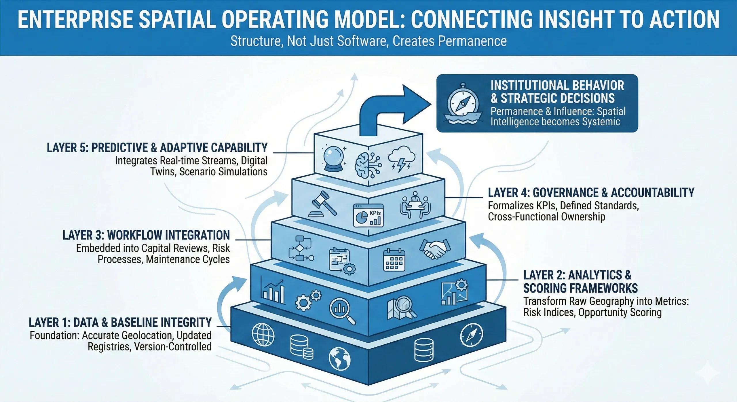
The Five Layers of the Enterprise Spatial Operating Model
A practical model typically contains five connected layers.
Layer 1: Data & Baseline Integrity
Foundation elements:
Accurate geolocation
Updated asset registries
Environmental and risk layers
Version-controlled spatial datasets
If the baseline is wrong, every decision built on it compounds error.
This layer ensures spatial truth.
Layer 2: Analytics & Scoring Frameworks
This layer transforms raw geography into metrics:
Risk exposure indices
Opportunity density scoring
Service accessibility metrics
Climate vulnerability overlays
The key shift: from maps to structured scoring.
This enables comparability.
Layer 3: Workflow Integration
Spatial metrics must be embedded into:
Capital allocation reviews
Risk committee processes
Maintenance prioritization cycles
Expansion planning frameworks
If geography is not required in workflow gates, it remains advisory.
This layer ensures influence.
Layer 4: Governance & Accountability
This layer formalizes:
Spatial KPIs in executive dashboards
Board-level exposure reporting
Defined decision standards
Cross-functional ownership
This ensures continuity beyond individual champions.
Layer 5: Predictive & Adaptive Capability
The final layer integrates:
Real-time data streams
Scenario simulations
Digital twins
AI-assisted prioritization
Here, spatial intelligence becomes dynamic rather than periodic.
A practical example
Consider a national infrastructure enterprise.
Without an operating model:
GIS produces reports
Finance allocates capital
Risk teams maintain registers
Operations prioritize independently
With a Spatial Operating Model:
Risk scoring informs capital sequencing
Expansion proposals require geographic impact metrics
Climate projections influence asset reinforcement
Board dashboards display concentration indices
The same data exists.
But now it flows through a defined architecture.
Why operating models matter more than tools
Organizations often upgrade platforms.
Few redesign operating models.
The result:
Insight without enforcement
Metrics without mandate
Dashboards without consequence
Operating models convert capability into institutional behavior.
Where most enterprises stall
Common gaps include:
No defined spatial decision standards
Weak integration with financial systems
Lack of executive ownership
Poor change management
Fragmented data governance
Without architectural clarity, spatial intelligence remains experimental.
The monetization bridge
As organizations mature, they increasingly seek structured advisory support and scalable spatial decision platforms that align data governance, workflow integration, KPI alignment, and predictive capability into a unified operating model. The value lies not in deploying tools, but in designing decision architecture.
Looking ahead
The future enterprise will not separate spatial from strategic.
Location will be embedded into:
Enterprise architecture
Capital strategy
Risk governance
ESG reporting
Operational command systems
The operating model will determine whether spatial intelligence is episodic, or systemic.
Closing insight
Tools create possibility.
Operating models create permanence.
The enterprises that win will not simply adopt geospatial systems.
They will architect how geography influences every decision.