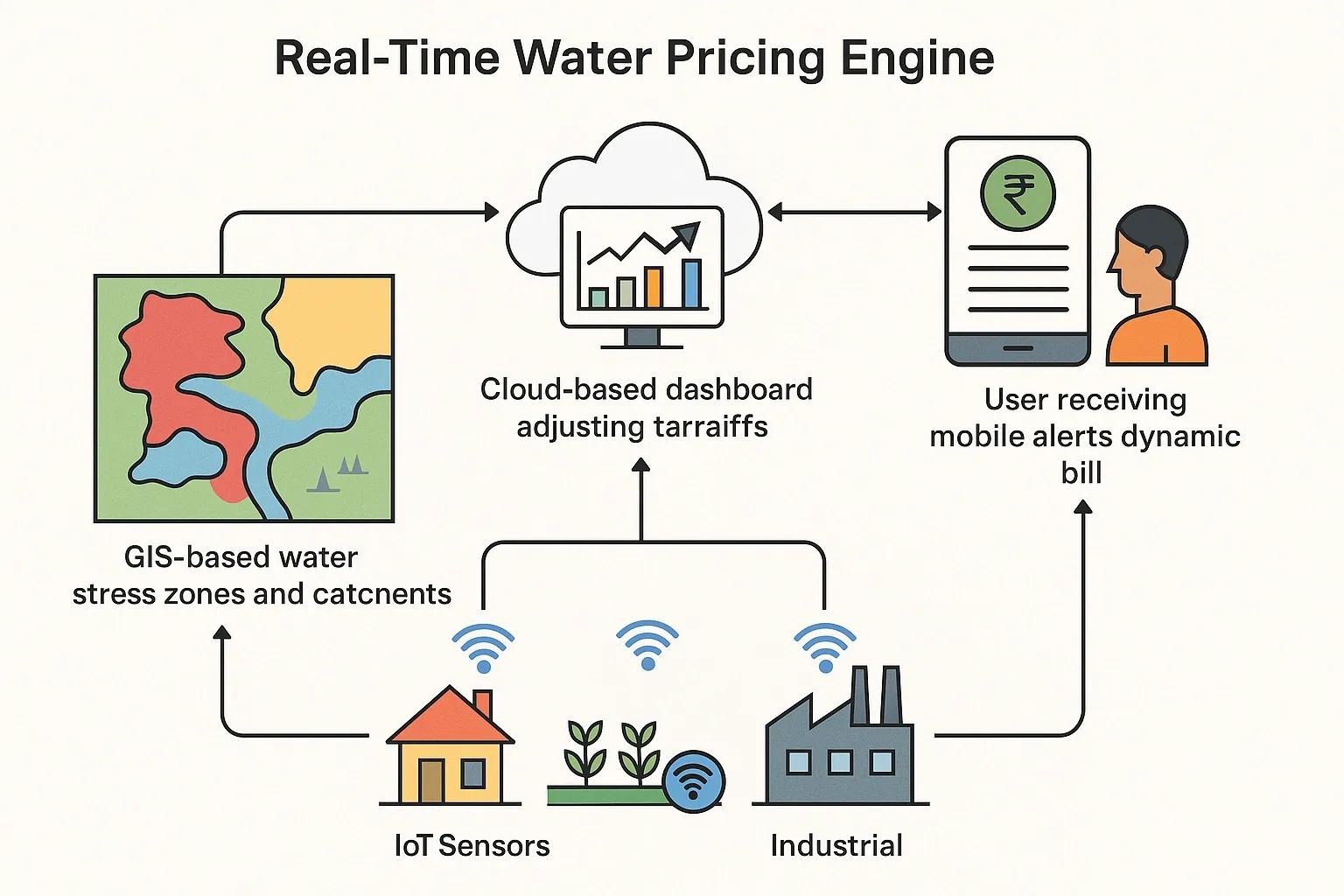
Water scarcity is no longer a looming challenge, it is a present and intensifying crisis. Traditional water pricing models, which are typically flat-rate or block-tariff-based, fail to reflect the actual stress on water resources or user behavior. As urbanization, agricultural intensification, and climate variability strain water systems, a more adaptive, data-driven pricing model is required. This is where dynamic water pricing using IoT and GIS technologies emerges as a powerful solution.
This article explores how real-time consumption data from IoT sensors, combined with geospatial insights from GIS, can inform a responsive water pricing mechanism that promotes efficient usage, equity, and resource sustainability.
Understanding Dynamic Water Pricing
Dynamic pricing in the water sector refers to adjusting tariffs in near-real-time based on factors such as:
Usage levels (per household, field, or industrial unit)
Water availability in catchments or reservoirs
Demand fluctuations
Infrastructure stress or maintenance schedules
Instead of static tariffs, dynamic pricing responds to supply-demand dynamics, encouraging conservation during shortages and ensuring affordability when resources are abundant.
Role of IoT in Water Usage Monitoring
Internet of Things (IoT) devices, particularly smart water meters, play a crucial role in real-time monitoring and transmission of water usage data. These meters are installed at residential, agricultural, and industrial nodes and capture metrics such as:
Volume of water consumed
Time of use (peak vs. off-peak)
Leak detection and anomaly patterns
Flow rate and pressure variability
The data is sent to centralized servers or cloud platforms via cellular, LoRaWAN, or NB-IoT networks, enabling continuous tracking without manual intervention.
IoT-based telemetry also allows utilities to segment users based on consumption behavior, daily spikes, sustained overuse, or irregular use, thus enabling precise tariff adjustments or early intervention.
GIS: Spatial Context for Water Pricing
Geographic Information Systems (GIS) offer the spatial intelligence necessary to contextualize water use. GIS layers relevant to dynamic pricing include:
Hydrological data : Catchment area maps, groundwater recharge zones, reservoir levels
Land use classification : Urban, agricultural, industrial zones
Climate data : Rainfall distribution, drought zones, evapotranspiration rates
Infrastructure mapping : Water supply lines, treatment facilities, pumping stations
Socioeconomic indicators : Population density, income levels, informal settlements
By combining this data, GIS helps in defining water stress zones where supply is limited, and demand hotspots where pricing should be strategically adjusted.
How Dynamic Water Pricing Works: An Integrated Architecture
A typical dynamic pricing system using IoT and GIS follows this process:
Sensor Deployment & Data Capture Smart meters collect usage data at high resolution (e.g., hourly). Flow sensors monitor source-level discharge and pipeline leakage.
Geospatial Layering Usage data is linked with land parcel maps, zoning information, and climate data. Catchment-level availability is monitored using satellite and in-situ hydrological data.
Central Data Platform A cloud-based platform integrates IoT telemetry and GIS maps. Real-time dashboards display supply-demand balance, pressure drops, and consumption clusters.
Tariff Algorithm Engine Algorithms dynamically compute water tariffs based on: Consumption volume Time of use Catchment stress index Local infrastructure capacity For instance, water from a high-stress zone may carry a premium charge.
User Notification & Billing Users are notified through mobile apps or dashboards about tariff changes. Bills are auto-generated based on real-time pricing models.
Feedback & Optimization AI/ML models continuously refine tariff rules based on consumption patterns, rainfall forecasts, or system efficiency.
Applications Across Sectors
1. Urban Utilities
Smart cities can apply dynamic pricing to discourage overuse during peak hours or droughts. For instance, high-income households using excessive water for gardens or swimming pools can be billed at a higher slab, while ensuring lifeline tariffs for economically weaker sections.
2. Agricultural Irrigation
By integrating with GIS-based soil moisture data and rainfall forecasts, dynamic pricing can incentivize farmers to adopt drip irrigation or schedule water use efficiently. IoT-integrated flow meters on borewells help monitor groundwater extraction and enforce tariffs based on aquifer stress.
3. Industrial Clusters
Industrial units in water-stressed areas can be subjected to higher tariffs to discourage inefficient cooling systems or untreated discharges. GIS zoning ensures region-specific pricing models tied to local recharge capacity.
Benefits of Dynamic Pricing
Demand Management : Encourages users to shift consumption to off-peak times.
Equity : Allows lifeline water access while penalizing overuse.
Conservation : Reduces wastage and groundwater over-extraction.
Revenue Optimization : Enables utilities to adjust to seasonal revenue fluctuations.
Transparency : Empowers users with real-time visibility into usage and charges.
Challenges and Considerations
While promising, dynamic water pricing systems come with several challenges:
Data Privacy and Security : User data must be encrypted and securely stored.
Infrastructure Investment : Initial costs for meters, sensors, and platforms can be high.
Digital Divide : Users without smartphones or internet access may face challenges in engaging with dynamic pricing platforms.
Regulatory Frameworks : Water is a sensitive and often subsidized resource; tariff revisions must balance affordability and sustainability.
Global Examples
Singapore's PUB uses smart meters and pricing models to manage limited water resources through public dashboards and real-time feedback.
Spain's Murcia Region implements satellite-linked irrigation advisories and volumetric pricing based on crop water requirements and supply levels.
California, USA pilots dynamic pricing in drought-prone areas using advanced metering and GIS-linked groundwater tracking.
Future Outlook
The convergence of real-time IoT data, spatial analytics, and AI-driven decision systems is shaping a future where water is not just priced as a utility but managed as a strategic, shared resource. Emerging trends like blockchain-based water credit trading , satellite-enabled aquifer monitoring , and AI-guided leak detection will further mature dynamic pricing ecosystems.
For India and other water-stressed countries, integrating smart pricing mechanisms into urban reform programs (AMRUT 2.0), smart agriculture missions, and catchment management frameworks offers a scalable pathway for sustainable water governance.
Conclusion
Dynamic water pricing powered by IoT and GIS represents a shift from reactive to proactive water management. It promotes behavioral change, ensures sustainable resource allocation, and empowers utilities to balance conservation with cost recovery. As water becomes an increasingly contested commodity, data-driven pricing will be central to building resilient and equitable water systems.