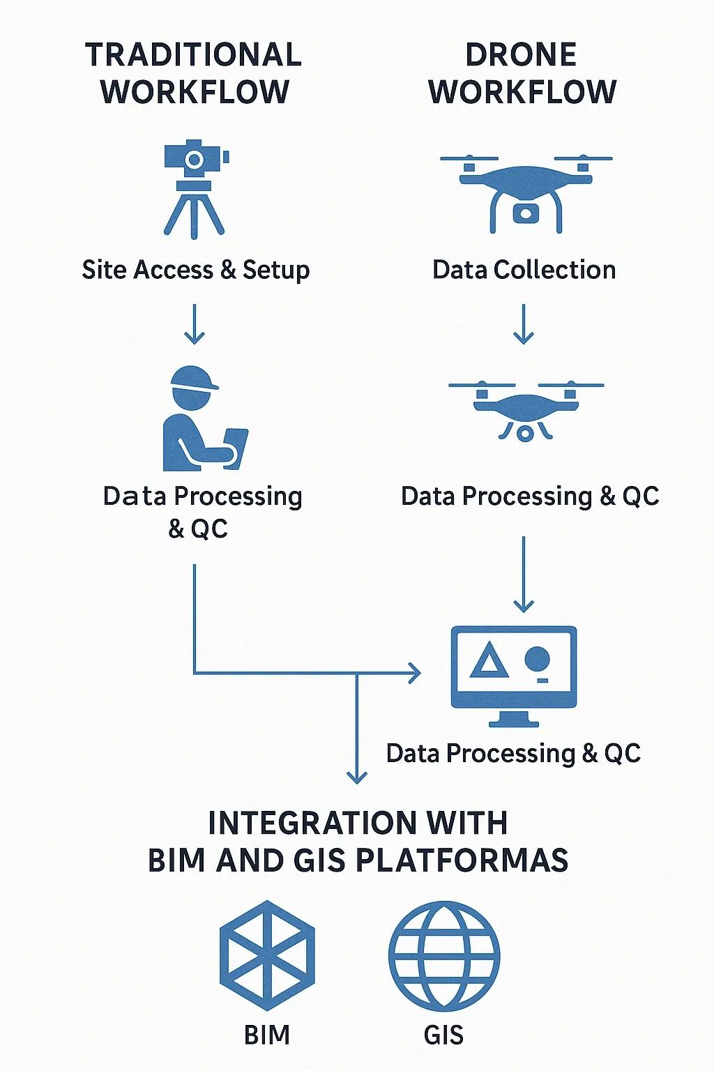
In the Architecture, Engineering, Construction, and Operations (AECO) sector, the initial stages of a project, particularly site analysis and survey, have long relied on manual methods and ground-based instruments. However, these traditional methods are often time-consuming, labor-intensive, and prone to inaccuracies, especially in large or inaccessible areas. With the advent of drone-based surveys, organizations can now capture high-resolution geospatial data with unprecedented speed, cost-efficiency, and precision.
This article explores how drone-based surveys are transforming project startups, particularly in topographic mapping and progress tracking, offering a compelling alternative to conventional surveying practices. The discussion includes use cases, comparative benefits, integration with other digital tools like BIM and GIS, and future trends shaping this technology.
The Traditional Survey Bottleneck
Traditional land surveys require teams of skilled personnel using total stations, GPS receivers, and manual measurements to capture topographic data. This process typically involves:
Several site visits over days or weeks
Manual setting of ground control points
Restricted access in hazardous or difficult terrains
Gaps in spatial coverage due to physical or logistical constraints
Potential safety risks in high-traffic or industrial zones
In large-scale infrastructure or greenfield projects, these limitations often delay project approvals, increase startup time and costs, and introduce rework risks due to data inaccuracies.
Enter Drone-Based Surveys
Unmanned Aerial Vehicles (UAVs), or drones, equipped with RGB, LiDAR, or multispectral sensors are now widely used to conduct aerial surveys. A single drone flight can capture thousands of geotagged images or point cloud data over a few hours, covering tens or hundreds of hectares. These datasets are then processed using photogrammetry software to generate:
Orthomosaic maps
3D terrain models
Digital Elevation Models (DEMs)
Contour maps and volumetric analyses
Construction progress heatmaps
This transformation in data acquisition is fundamentally changing how projects are initiated.
Key Benefits of Drone-Based Surveys
1. Speed and Efficiency
Drone surveys drastically reduce the time needed to survey a site. For instance, an area that may take a team of four surveyors three days to cover using traditional tools can be mapped by a drone in under an hour.
Example: In a highway expansion project in Karnataka, India, drone-based mapping enabled full corridor visualization in just 2 days, a task estimated at over 10 days with conventional methods.
2. Cost Savings
Despite the initial investment in drone hardware and software, the overall cost per survey is lower due to reduced labor, fewer site visits, and faster data turnaround. The automation of data processing also decreases reliance on external CAD/GIS technicians.
Case Insight: A real estate developer in Telangana saved nearly 40% of its preliminary survey budget by switching to drone-based topographic assessments for a 100-acre residential layout.
3. Higher Accuracy and Resolution
Drones can capture high-resolution imagery (up to 1 cm/pixel) and generate point clouds with accuracy within 2-5 cm when combined with RTK/PPK GPS corrections and well-placed ground control points. This level of precision is ideal for grading, excavation, and volumetric analysis.
4. Access to Inaccessible or Hazardous Areas
Drones easily reach locations that are dangerous or time-consuming for humans, steep slopes, marshes, high bridges, mines, or busy road corridors. This improves safety and ensures better data completeness.
5. Real-Time Progress Monitoring
Progress surveys during construction can be carried out on a weekly or monthly basis using drones, enabling:
Visual comparisons with planned milestones
Early detection of schedule slippage or site misuse
Stakeholder reporting through interactive 3D maps
This is a key enabler for lean construction and remote project management.
Use Cases in AECO and Beyond
Application - How Drones Help
Topographic Surveying - Rapid and detailed terrain mapping without ground interference
Earthwork Calculation - Accurate cut-and-fill volume estimations
Road & Rail Corridor Planning - Linear mapping with elevation and slope profiling
Utility Line and Pipeline Routing - Route optimization with terrain and obstruction visibility
Construction Progress Documentation - Regular aerial updates for project stakeholders
Disaster Recovery Assessments - Fast damage quantification after floods, landslides, etc.
Integration with BIM, GIS, and Digital Twins
Drone survey data is increasingly being integrated into Building Information Modeling (BIM) and Geographic Information Systems (GIS) platforms to enable seamless project planning and execution:
BIM Integration : Point clouds and orthomosaics feed into 3D models for clash detection, structural validation, and virtual walk-throughs.
GIS Integration : Spatial datasets support zoning, land use classification, and infrastructure overlays.
Digital Twins : Real-time drone inputs enhance situational awareness in Digital Twin environments, especially for large campuses or industrial sites.
Such integrations enable data-driven decisions across the asset lifecycle, from feasibility to operation.
Comparative Timeline: Traditional vs. Drone Survey
Activity - Traditional Survey - Drone-Based Survey
Site Access & Setup - 1–2 Days - 0.5 Day
Data Collection - 3–5 Days - 1 Day
Data Processing & QC - 3 Days - 1 Day (automated)
Total Turnaround - 7–10 Days - 1.5–2 Days
Such efficiency gains make drone surveys a strategic asset, particularly in fast-track projects or EPC (Engineering, Procurement, and Construction) contracts.
Regulatory Considerations
In India, drone operations for commercial surveys must comply with the Drone Rules, 2021 and operate within the Digital Sky Platform for flight permissions. Certified remote pilots and approved survey zones are prerequisites for legal compliance. Similar regulations exist globally, enforced by DGCA (India), FAA (USA), and EASA (Europe).
Companies must ensure:
Drones are registered
Pilots are licensed
Permissions are taken before flying in restricted zones
Challenges and Mitigations
Despite the advantages, there are some practical challenges:
Challenge - Mitigation
Weather Dependency - Use drones with obstacle detection and wind tolerance
Data Overload - Use automated cloud-based analytics tools
Skill Gap - Partner with drone survey firms or train in-house teams
GPS Interference in Urban Areas - Use RTK drones or post-processing with ground control
These limitations can be minimized with proper planning, experienced operators, and quality control protocols.
The Future: AI, BVLOS, and Autonomous Surveys
Drone surveys are evolving rapidly with AI-powered object recognition, autonomous flight planning, and BVLOS (Beyond Visual Line of Sight) capabilities. In the near future, we can expect:
Autonomous, schedule-based drone surveys for large industrial campuses
AI-driven anomaly detection in real-time survey imagery
Integration with IoT and 5G for live geospatial monitoring
Cross-linking with project scheduling tools like MS Project for automated progress updates
These trends align with the larger shift toward digital transformation and predictive project management in infrastructure development.
Conclusion
Drone-based surveys are revolutionizing how projects begin and evolve, especially in sectors like construction, infrastructure, agriculture, and energy. By replacing manual, slow, and costly methods with high-speed aerial mapping and intelligent data analytics, project stakeholders can make faster decisions, reduce errors, and optimize resources from day one.
As regulatory frameworks mature and drone technologies become more affordable, their adoption is set to become standard practice in project startups globally. For organizations aiming to stay competitive, embracing drone-based surveys is no longer a futuristic idea, it’s a present-day advantage.