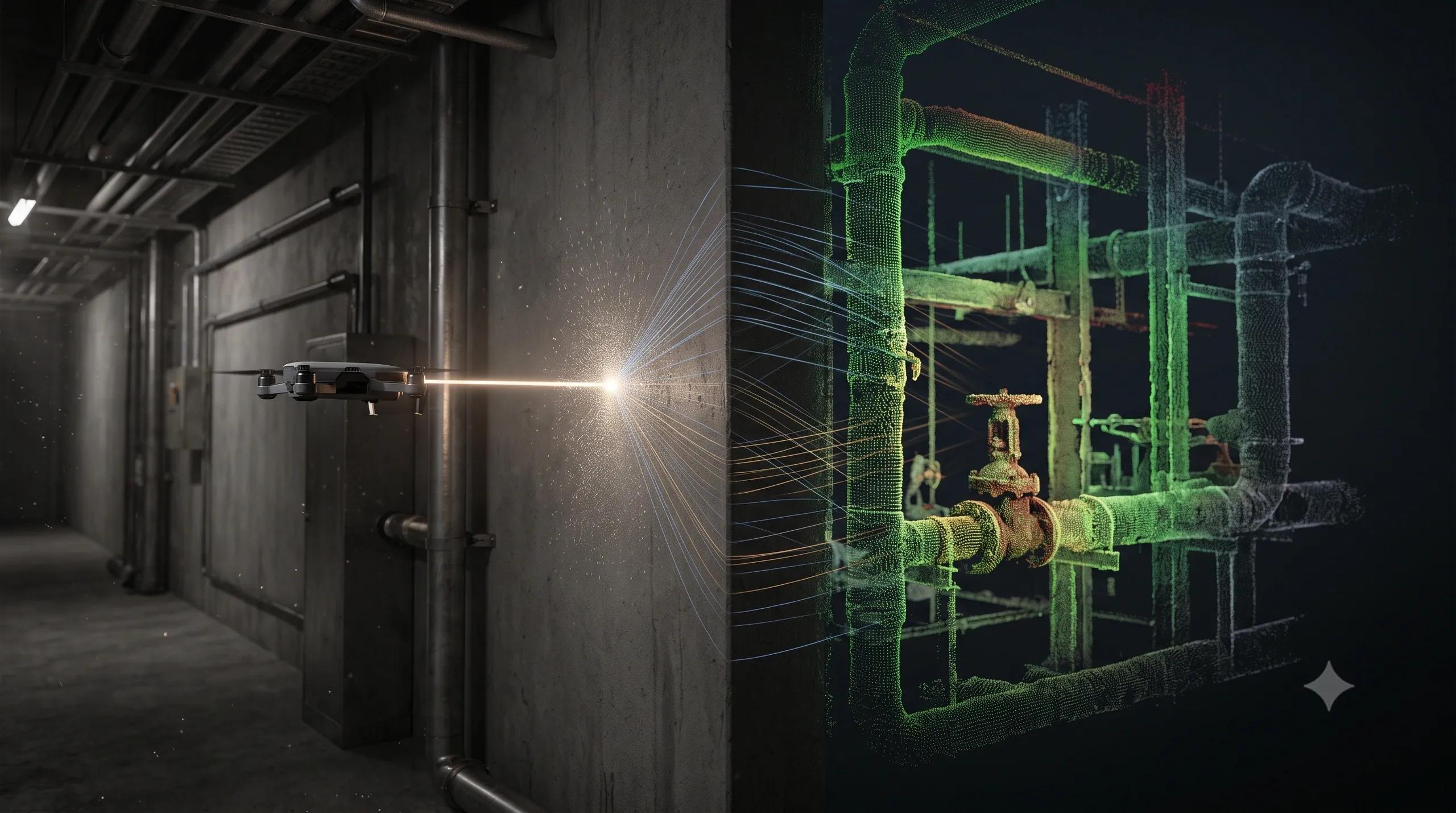
Every reality-capture project has blind spots.
A laser scanner cannot capture what is hidden behind a structural column. A drone cannot safely enter every collapsed passage. A mobile-mapping system may record the front of a dense industrial pipe rack while missing the assets concealed behind it.
We usually compensate by adding more scanning positions, conducting manual inspections, combining multiple sensors or estimating the missing geometry.
But some parts of the physical environment remain invisible.
This creates what I call the occlusion gap : the difference between the physical environment that actually exists and the portion that our sensors can directly observe.
Non-Line-of-Sight imaging could help close that gap.
What Is Non-Line-of-Sight Imaging?
Non-Line-of-Sight, or NLOS, imaging is a computational imaging technique that reconstructs objects or spaces hidden from the direct view of a sensor.
It is often described as technology that can “see around corners.”
However, it should not be confused with X-ray imaging. Optical NLOS systems do not normally see directly through opaque walls. Instead, they use light reflected from a visible surface, ‘such as a wall, floor or ceiling’ to collect information about a hidden area around an obstruction.
A typical active NLOS process works like this:
An ultrashort laser pulse is directed towards a visible relay surface.
The light scatters from that surface into the hidden area.
Some photons reflect from hidden objects and return to the relay surface.
A highly sensitive detector records the arrival time of the returning photons.
A reconstruction algorithm estimates the position, shape or movement of the hidden objects.
This concept outlines this bounce–scatter–return–reconstruction process and its relevance to UAVs, BIM, XR and digital twins.
Many experimental systems use Single-Photon Avalanche Diodes, or SPADs, to measure photon arrival times with extremely high temporal precision. The reconstruction software then solves an inverse problem: it works backwards from the indirect light measurements to estimate the hidden scene.
This is not simply a more powerful form of LiDAR.
It is a different sensing model.
Traditional LiDAR measures direct light paths. NLOS imaging extracts spatial information from light that has travelled through multiple indirect paths.
Why This Matters for Digital Twins
The value of a digital twin depends on how accurately it represents the physical environment.
When critical areas are missing, the twin may look complete while still containing operational blind spots.
This is especially common in brownfield environments:
Industrial plants with dense machinery and pipe networks
Underground mines and tunnels with complex intersections
Buildings with congested service areas
Warehouses with frequently changing layouts
Infrastructure damaged by fire, collapse or natural disasters
Today, teams often fill these gaps using engineering drawings, historical records, assumptions or manually created geometry.
That introduces geometry debt .
The model may appear continuous, but portions of it are not based on current observation. Over time, these assumptions can affect maintenance planning, safety assessments, clash detection and operational decisions.
NLOS imaging could become a supplementary reality-capture layer that targets these difficult zones.
It would not replace LiDAR, photogrammetry, radar or conventional inspection. It would be used selectively where direct visibility is limited, access is dangerous or collecting another scan would be expensive.
Where NLOS Could Create Operational Value
Industrial facilities
Refineries, manufacturing plants and utility facilities contain rows of machinery, structural frames, cables and pipe racks.
Capturing every asset may require many scanner positions and repeated shutdown access.
An NLOS-enabled system could potentially inspect selected blind zones from a safer position, providing additional geometry before a worker, robot or UAV enters the area.
The immediate benefit would not be a perfect hidden-scene model. It would be better situational awareness and more informed inspection planning.
Tunnels, mines and damaged infrastructure
Robots and UAVs are increasingly used to inspect environments that are unsafe for people.
However, the platform still needs to travel far enough into the environment for its sensors to obtain a direct view.
NLOS sensing could allow a robot to examine an intersecting tunnel, hidden chamber or area behind debris before proceeding. Research systems have already demonstrated the reconstruction and tracking of hidden scenes and moving objects around corners, although practical field deployment remains challenging.
Autonomous systems
A vehicle, warehouse robot or industrial autonomous platform cannot react to an object it has not yet detected.
NLOS perception could provide an early warning of a pedestrian, vehicle or moving asset approaching from behind an obstruction.
In this context, even partial information may be valuable. The system may not need a detailed 3D model. It may only need to know that something is approaching, its direction and its approximate speed.
BIM-to-field validation
NLOS imaging is sometimes presented as a way to see behind walls. That description requires caution.
Optical NLOS is better suited to seeing around occlusions through available relay surfaces than detecting assets through solid building materials. Technologies such as ground-penetrating radar, thermal imaging and electromagnetic sensing remain more appropriate for many through-material inspection tasks.
The more realistic BIM use cases are service corridors, open ceiling voids, equipment rooms, partially accessible cavities and zones obstructed by installed assets.
Here, NLOS could supplement scan-to-BIM workflows by reducing the number of unresolved areas within the as-is model.
Immersive XR for field operations
Once hidden geometry has been reconstructed and spatially registered, it could be displayed through an XR headset.
An engineer or first responder might receive a confidence-coded indication of an object, passage or hazard beyond the visible corner.
But the overlay must clearly distinguish between directly measured geometry and computationally inferred geometry. Otherwise, XR could create false confidence rather than improve situational awareness.
The NLOS-to-Digital-Twin Pipeline
For NLOS to become useful in an operational digital twin, the technology must extend beyond image reconstruction.
A practical pipeline would require:
Sensing: Ultrafast illumination and highly sensitive time-resolved detectors collect indirect light measurements.
Spatial calibration: The sensor, relay surface and existing environment must share a reliable coordinate framework.
Transient processing: Background light, noise and unwanted reflections must be separated from useful photon returns.
Reconstruction: Physics-based or AI-supported algorithms estimate hidden geometry, reflectance or movement.
Confidence modelling: Every reconstructed object should include uncertainty, resolution and reliability information.
Twin integration: The output must be connected to GIS, BIM, asset registers or operational systems rather than remaining as an isolated point cloud.
Change analysis: Repeated observations should determine whether a hidden asset has moved, appeared, disappeared or changed condition.
This confidence layer is essential.
NLOS data should not enter a digital twin as unquestioned geometric truth. Its origin, processing method and level of uncertainty must remain visible to downstream users.
What Is Holding the Technology Back?
NLOS imaging still faces major constraints.
Only a very small portion of the emitted light completes the multi-bounce journey and returns to the sensor. This produces extremely weak signals and makes the system sensitive to ambient light, surface properties, distance and sensor noise.
Reconstruction may also require significant computation. Resolution and capture speed can fall below what operational users expect from conventional scanners.
Research is addressing these limitations through faster reconstruction, sparse measurement strategies, improved neural models and methods that support more practical relay surfaces. A June 2026 preprint, for example, explored NLOS reconstruction using spatially limited and arbitrarily shaped relay regions rather than assuming a large, flat wall.
Other work has demonstrated low-latency reconstruction and moving-scene capture, but the technology is not yet a standard field-ready component of commercial reality-capture workflows.
AI will improve the reconstruction process, but it cannot manufacture reliable geometry when the physical signal is insufficient.
The physics, calibration and validation remain fundamental.
How Organisations Should Evaluate NLOS
The right starting point is not to ask:
“Can this technology map our entire facility?”
A better question is:
“Which operational blind spot is expensive, dangerous or difficult enough to justify a new sensing method?”
A focused pilot could select one high-value occluded area and compare NLOS reconstruction against verified ground-truth measurements.
The evaluation should measure:
Additional area or geometry captured
Accuracy and repeatability
Reduction in inspection access
Time saved during reality capture
Improvement in safety or decision readiness
Ease of integration with the existing digital twin
The strongest early business cases will probably be environments where access risk and operational disruption cost more than the sensing complexity.
From Visible Reality to Computed Reality
Reality capture has traditionally meant recording surfaces that a sensor can directly observe.
NLOS imaging introduces a new possibility: reconstructing parts of reality through indirect evidence.
This will also change how we think about digital twins.
Future twins may contain a combination of directly measured geometry, inferred geometry, predicted conditions and simulated outcomes. Their value will depend not only on visual completeness, but also on whether users understand how each part of the model was created and how much confidence they should place in it.
NLOS imaging will not eliminate line-of-sight sensing.
It could, however, help us capture the areas that LiDAR, cameras and UAVs leave behind.
The next frontier in reality capture may therefore be less about improving how clearly we see what is in front of us and more about responsibly reconstructing what remains hidden.