The Himalaya Needs More Than Maps. It Needs a Twin.
The Himalaya is a system of systems, glaciers, snowpack, permafrost, rivers, slopes, clouds, hazards, and infrastructure all interacting across altitude and time.
Traditional GIS gives us layers.
Models give us predictions.
But the region needs something more unified, an always-on, multi-layer operational brain that brings them all together.
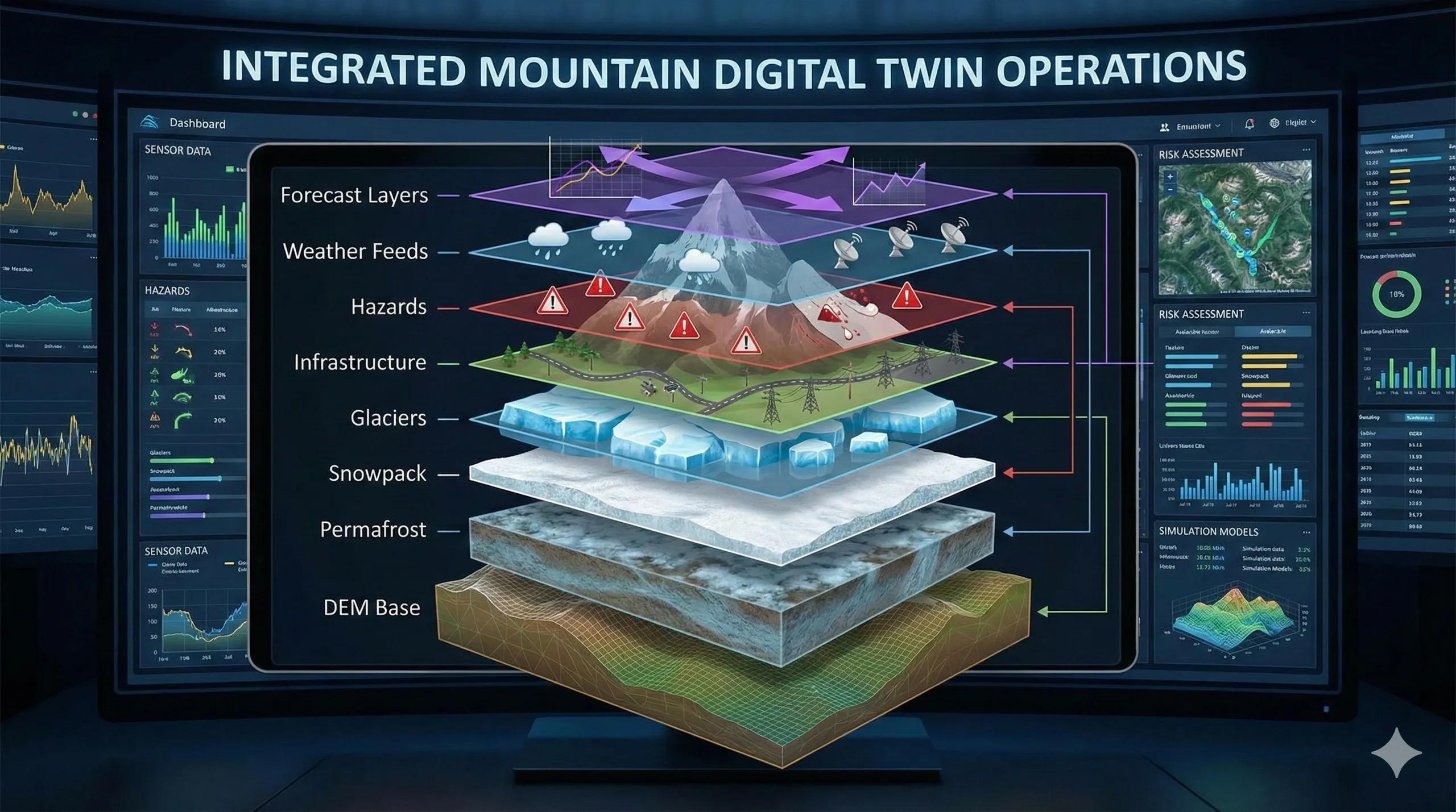
That’s the promise of Mountain Digital Twins : dynamic, data-driven replicas of high-altitude environments, built to support decisions in climates where minutes matter.
A mountain digital twin is not a model.
It’s a continuously updating operational layer that lives between the mountain and the decision-maker.
Why Mountains Need Digital Twins
Unlike plains or cities, mountains change fast and unpredictably:
Avalanches release within minutes
GLOF pathways evolve with lake volume
Permafrost deformation accelerates with temperature
Snowmelt pulses shift river discharge weekly
Landslide creep accelerates after one rain event
Glacier thinning alters hydrology year to year
A digital twin provides situational awareness across all these domains in one place.
The Architecture: Multi-Layer Mountain Twin
A mountain digital twin brings nine essential layers into one cloud-driven model:
1️⃣ Terrain Core (The Base Layer)
TanDEM-X / ALOS / Planet DEM
Slope, aspect, curvature, ridge/valley networks
Provides the geometric skeleton of the mountain.
2️⃣ Cryosphere Layer
Snow cover (Sentinel-2, MODIS)
SWE & depth (SAR + reanalysis)
Glacier thickness & dh/dt (ICESat-2 + SAR)
Rock glacier movement
Tracks seasonal and long-term ice dynamics.
3️⃣ Hydrology Layer
Snowmelt models (degree-day / energy balance)
River routing
Glacial lake volumes
Snowmelt and rainfall runoff models (HEC-RAS/2D)
Simulates mountain water systems in real time.
4️⃣ Permafrost & Ground Stability
Ground temperature + LST
InSAR subsidence
Active rock glaciers
Captures freeze-thaw impacts and terrain deformation.
5️⃣ Weather & Climate Layer
Near-real-time temperature, snowfall, radiation
Radar nowcasting
ERA5 climate anomalies
Provides short-term and long-term atmospheric drivers.
6️⃣ Hazard Layer
Avalanche susceptibility (slope × aspect × snowfall)
GLOF breach scenarios
Landslide early warning (InSAR + rainfall triggers)
Snowmelt flood risk
A unified spatial hazard engine.
7️⃣ Infrastructure Layer
Roads, tunnels, bridges
Hydropower projects
Transmission lines
Settlements & military posts
Shows exposure and vulnerability.
8️⃣ Human-Use Layer
Tourism routes
Grazing patterns
Camps, shelters, patrol bases
Links physical hazards with real human presence.
9️⃣ Forecast & Simulation Layer
Seasonal snowmelt forecasting
Lake breach propagation
Avalanche release scenarios
Climate-driven glacier mass balance
Turns observation into actionable forecasting.
Multi-Layer Operations: What the Twin Does
Unlike static GIS, a mountain digital twin performs operations in real time:
A. Detects
New avalanches (Sentinel-1 wet snow signature)
Lake expansion (Sentinel-2 + SAR)
Glacier acceleration (feature tracking)
Subsidence (InSAR time-series)
B. Predicts
Daily runoff
Avalanche release windows
GLOF breach impacts
Permafrost slump risk
C. Alerts
High-SWE melt zones
Heavy snowfall on avalanche slopes
Rapid deformation hotspots
Cloudburst-prone basins
D. Advises
When to open high-altitude corridors
Safe-time windows for BRO/Army logistics
Hydropower scheduling
Snow clearance and patrol timing
Early evacuation triggers
In essence, the twin becomes a decision-support engine for the mountains.
Case Example: Digital Twin for a Himalayan Valley
A prototype twin for a 140-km Himalayan corridor integrates:
Sentinel-1 (6-day SAR)
Sentinel-2 (10 m optical)
ICESat-2 elevation profiles
IMD weather feeds
HEC-RAS flood models
ERA5 temperature anomalies
The system outputs:
Avalanche corridor updates every 6 days
Daily snowmelt discharge forecasts
30-day flood risk outlook
Glacier retreat dashboards
Permafrost deformation maps
Road exposure heatmaps
This became the operational backbone for planning logistics and climate-risk interventions.
GeoAI: The Brain of the Mountain Twin
AI models enable:
LSTM snowmelt forecasts
CNN rock glacier detection
Random Forest avalanche scoring
GNN hazard-infrastructure risk networks
Transformers for multi-sensor fusion
GeoAI compresses huge mountain datasets into one interpretable intelligence layer .
The Future: A Pan-Himalayan Digital Twin
Imagine a unified twin stretching from:
Ladakh → Himachal → Uttarakhand → Nepal → Sikkim → Arunachal
Feeding:
NDMA + IMD
BRO & Armed Forces
State disaster authorities
Hydropower boards
Research universities
Tourism and environmental planning agencies
A Himalayan twin would not map the mountains, It would let the mountains speak.
Conclusion
Mountain Digital Twins are the next evolution of high-altitude geospatial intelligence.
They combine DEMs, snowpack, glaciers, hazards, climate signals, and infrastructure exposure into one continuously updating decision engine.
In a region where terrain hides reality and weather changes rapidly, a digital twin becomes not just a mapping tool, but a mountain operations system.