Why this matters now (India + global): As enterprises modernize operations, leaders are asking for XR-ready digital twins , twins that not only mirror real-time conditions but also understand space (geometry, location, occlusion, and context) so technicians can act faster and safer. For AEC, manufacturing, utilities, and smart cities in India and beyond, the payoff is straightforward: fewer errors, faster training, and higher asset uptime.
What is an XR-ready digital twin?
A digital twin is a living data model of a physical system. An XR-ready twin adds three capabilities:
Spatial intelligence: The twin understands coordinate frames, anchors, and environments; it can answer “where” with precision.
Real-time awareness: The twin fuses sensor streams (IoT/SCADA), logs, and events with BIM/GIS context.
Immersive delivery: Twin insights render in AR/VR/MR with stable alignment, good performance, and intuitive interaction (voice/gesture).
Mid-article question: Would your team gain more from AR field guidance or VR training simulations in the first 90 days?
Reference framework (at a glance)
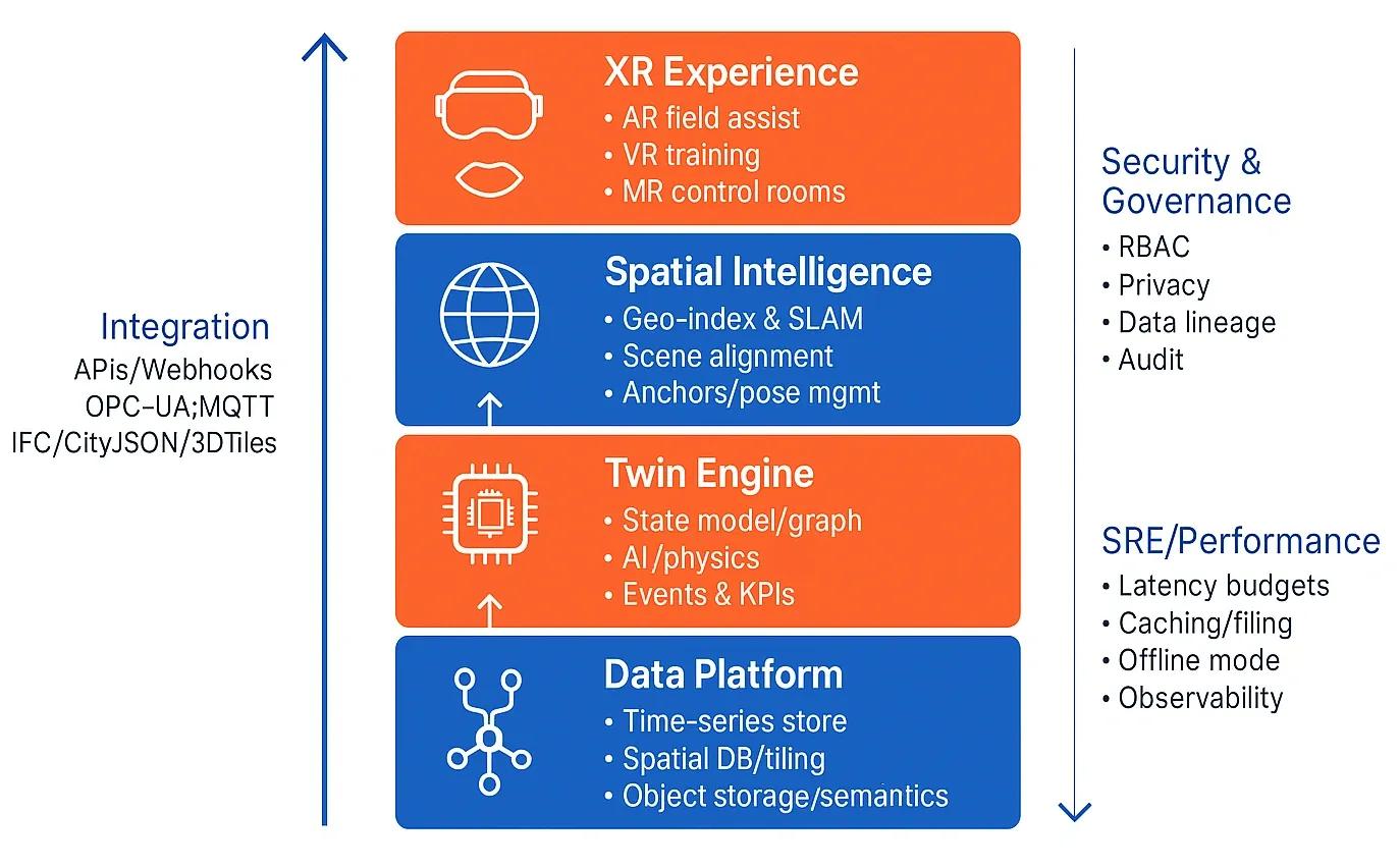
Use this stack to evaluate or design your own solution (also see Figure 1 in the visual):
Data ingestion: IoT/SCADA, UAV imagery, Lidar, logs, and enterprise systems.
Data platform: Time-series store, spatial database/tiling, object storage, metadata catalog.
Twin engine: State model and graph, physics and business rules, AI inference, KPI/eventing.
Spatial intelligence: Global/local coordinate frames, anchors, SLAM alignment, scene graph, spatial queries.
XR experience: Rendering (3D tiles/PBR assets), occlusion/lighting, UX (voice/gesture), offline mode.
Integration/governance: APIs and webhooks, BIM/GIS interop (IFC, CityJSON, 3D Tiles), RBAC, lineage, privacy, observability/SRE.
Data and models: making the twin “spatially intelligent”
1) Anchors and frames:
Define a single source of truth for coordinate reference systems (project CRS, site local, device pose).
Store anchors (persistent spatial markers) and relationships (e.g., “Pump-17 is 2.3 m north of Anchor-A”).
Use scene graph + spatial index (R-tree, BVH) for fast culling and queries in XR.
2) BIM + GIS fusion:
BIM gives component semantics (e.g., valve type, maintenance history).
GIS gives location and context (terrain, utilities, permissions).
Normalize IDs and metadata so a valve in IFC maps cleanly to a feature in GIS and an entity in the twin graph.
3) Live signals and semantics:
Bind sensors to entities via semantic bindings (asset_id ↔ sensor_topic).
Use event rules (“if vibration > threshold while temperature rising, flag bearing risk”).
Maintain versioned state so XR sessions can time-travel for root-cause analysis.
Rendering and interaction: XR that respects physics and context
Performance: Stream level-of-detail 3D tiles , lazy-load textures, and cache locally for spotty networks.
Occlusion and lighting: Use scene depth and environment probes for believable overlays.
Interaction: Hands-free voice/gesture for field tasks; for supervisors, MR dashboards pinned in space.
Safety: XR overlays must never block critical views ; apply dynamic transparency and snap-to-surface to reduce clutter.
AI in the loop: from “heads-up display” to decision support
Spatial AI: Pose estimation + SLAM for alignment. Object detection/segmentation on device or edge to identify components.
Predictive maintenance: Forecast failures with sensor+usage history. Surface next best action (NBA) with confidence.
Autonomous checks: Drones/AMRs scan sites, compare as-is vs as-built models, auto-log deviations, and push tasks into CMMS.
Security, governance, and SRE
Zero trust: Device, user, and twin service must all be authenticated (short-lived tokens).
RBAC/ABAC: Limit what each role can see or actuate; protect PII and sensitive layouts.
Lineage and audit: Track who changed models, rules, and anchors; keep a diff trail.
Observability: Define latency budgets (ingest → XR < 2 s for field alerts), monitor frame times, and error budgets.
Implementation playbook (90 days)
Phase 0 (1–2 weeks):
Pick one critical asset class (e.g., pumps) and a contained site .
Baseline KPIs: MTTR, first-time fix rate, training time.
Phase 1 (Weeks 3–6):
Stand up ingestion (MQTT/Kafka) and a minimal twin graph for the chosen assets.
Align BIM/GIS, define anchors, and publish a 3D tiles set for XR.
Phase 2 (Weeks 7–10):
Add rules and one predictive model; wire to a work-order system .
Ship an AR field assist scenario (locate, inspect, fix) + a VR training module (standard procedure).
Phase 3 (Weeks 11–12):
Measure KPI deltas; document ROI.
Decide scale-up and add more asset classes/sites.
Use cases
Construction (India AEC): AR model checks on site vs. IFC; auto-log deviations with geotagged photos; VR safety drills.
Manufacturing: MR line changeover guidance; digital work instructions; anomaly flags from vision systems.
Energy & utilities: AR fault localization on substations; VR emergency response; drone-to-twin inspections.
Benefits & ROI (typical ranges)
Training time: ↓ 30–50% with VR simulations.
First-time fix rate: ↑ 10–20% with AR procedures.
Unplanned downtime: ↓ 15–25% via early detection.
Onboarding quality: More consistent SOP adherence across teams.
Conclusion
XR-ready digital twins convert scattered data into spatially aware, on-the-job intelligence . Start small, anchor your models properly, keep latency low, and integrate with the systems your teams already use. The orgs that treat spatial intelligence as a first-class capability , not an afterthought, will see faster ramp-ups, safer sites, and higher asset availability.