Why This Shift Matters
Digital twins have spent many years being judged by how well they visualize reality.
A building model looked impressive.
A city model looked immersive.
A factory model looked detailed.
A road corridor looked measurable.
But the next phase of digital twins will not be defined only by visual quality.
It will be defined by how quickly a twin can help an organization move from field reality to operational decision.
That is where the digital twin pipeline is changing.
The Old Digital Twin Pipeline
The traditional pipeline was slow and fragmented.
Capture the site.
Process the data.
Build or update the model.
Publish the dashboard.
Ask experts to interpret the output.
Then decide what action to take.
This worked when a digital twin was mainly a planning or visualization asset.
But operational environments do not wait for perfect models.
Construction sites change every day. Roads deteriorate between inspections. Warehouses keep moving inventory. Utility corridors face vegetation, encroachment, weather, and access constraints. Industrial plants deal with safety, maintenance, quality, and production exceptions in real time.
In these environments, a digital twin cannot remain a static 3D representation.
It must become a decision-ready loop.
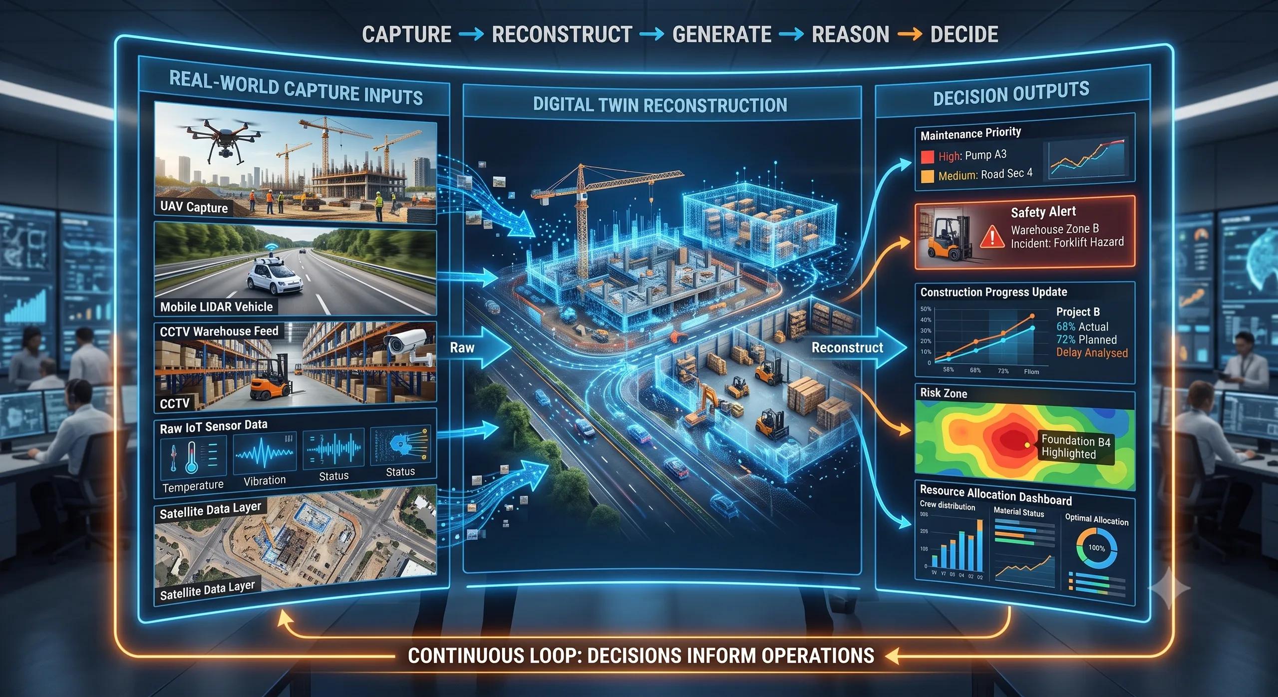
The New Loop: Capture, Reconstruct, Generate, Reason
That loop has four parts:
Capture. Reconstruct. Generate. Reason.
Capture brings real-world evidence into the system through drones, mobile mapping, CCTV, LiDAR, 360-degree cameras, IoT sensors, satellite imagery, and field photos.
Reconstruction converts that evidence into a spatial representation of the environment.
Generation helps fill gaps, simulate scenarios, test alternatives, or create future-state possibilities.
Reasoning connects the 3D environment to operational questions: What changed? What is blocked? What is unsafe? What is delayed? What should be inspected first? What action should be taken next?
This is the shift that matters.
The future digital twin will not only show what exists. It will help teams understand what it means.
Research Signals Pointing to This Direction
Recent research signals are pointing in this direction.
New work in Gaussian Splatting is reducing the friction of reconstructing 3D scenes from uncontrolled images. WildSplatter, for example, focuses on feed-forward 3D Gaussian Splatting from unconstrained images with unknown camera parameters and varied lighting conditions. That matters because real field data is rarely clean, controlled, or perfectly captured.
Other research is exploring the unification of 3D scene generation and reconstruction. PixWorld is positioned around bringing 3D scene generation and reconstruction into one pixel-space approach. SynCity 3000 is another signal, focused on scene-scale 3D diffusion for generating large 3D environments.
These are still research developments. They should not be treated as ready-made enterprise solutions.
But they show the direction clearly.
The boundary between captured reality, reconstructed geometry, and generated scenarios is becoming thinner.
What This Means for Geospatial Technology
This has major implications for geospatial technology.
Today, many organizations still treat digital twins as a final output. They complete a survey, build a model, and use it as a visual reference. But the higher value lies in treating the twin as a living spatial intelligence layer.
For example, in construction, the question is not only: “Can we create a 3D model of the site?”
The better question is: “Can we compare current site reality against the planned BIM schedule and identify what is delayed, missing, unsafe, or out of sequence?”
In roads and highways, the question is not only: “Can we map road condition?”
The better question is: “Can we reconstruct the corridor, detect deterioration, prioritize maintenance, and update the asset record continuously?”
In warehouses, the question is not only: “Can we visualize the facility?”
The better question is: “Can the twin understand movement, congestion, asset location, safety risk, and space utilization?”
In utilities, the question is not only: “Can we inspect an asset?”
The better question is: “Can we connect inspection evidence, vegetation risk, terrain, weather exposure, access routes, and maintenance priority into one decision layer?”
Why Reasoning Is the Real Breakthrough
This is where reasoning becomes important.
A 3D model knows geometry.
A semantic digital twin knows objects.
A decision-ready twin understands relationships.
It can understand that equipment is inside a restricted zone. A vehicle is blocking an access path. A stockpile is too close to a drainage channel. A worker is near a hazardous area. Vegetation is approaching a utility corridor. A construction element exists in the model but not yet on the ground.
Research in 3D scene graphs is moving exactly toward this type of relational understanding. Relationship-aware 3D scene graph work addresses the gap between metric reconstruction and higher-level object reasoning by representing objects, spaces, and relationships in a structured way arXiv .
This is an important lesson for the geospatial industry.
The next competitive advantage will not come from creating more layers.
It will come from connecting layers to decisions.
The Architecture Shift
A drone image, BIM model, GIS layer, IoT reading, CCTV feed, or point cloud has limited value when it remains isolated.
The value increases when the system can understand how these signals relate to one another.
That requires a different digital twin architecture.
Not just 3D visualization.
Not just a dashboard.
Not just AI added at the end.
It requires a spatial pipeline where reality is captured, reconstructed, semantically understood, tested against operational rules, and updated as the environment changes.
The Governance Layer Cannot Be Ignored
This also means we must be careful.
Generated 3D content can be useful, but it cannot replace field evidence. A digital twin that generates scenarios without traceability can become visually impressive but operationally risky.
For real-world use, every generated or AI-interpreted output must be tied back to evidence.
What data was captured?
When was it captured?
Which model interpreted it?
What confidence level was assigned?
What changed since the last update?
Which decision was made based on it?
Without this evidence chain, the twin may look advanced but fail in operations.
This is especially important in infrastructure, construction, climate risk, utilities, and industrial environments where decisions affect cost, safety, compliance, and public outcomes.
Start With the Decision, Not the Model
The practical opportunity for organizations is clear.
Do not start with the question: “How do we build a beautiful digital twin?”
Start with: “Which decision is slow, costly, risky, or repeatedly delayed because teams do not have current spatial intelligence?”
Then build the twin backwards from that decision.
If the problem is construction delay, connect BIM, drone progress, schedule, and site evidence.
If the problem is road maintenance, connect mobile imagery, defect detection, asset inventory, traffic exposure, and repair priority.
If the problem is utility risk, connect corridor imagery, vegetation analytics, terrain, weather, access, and maintenance planning.
If the problem is factory safety, connect CCTV, floor layout, equipment zones, movement patterns, and safety rules.
That is how digital twins become useful.
Closing Thought
The next digital twin pipeline will not end at visualization.
It will capture reality.
It will reconstruct change.
It will generate scenarios.
It will reason over relationships.
And most importantly, it will support better decisions.
That is the real step beyond 3D visualization.
At BSMA Enterprises , this is the direction we see for geospatial intelligence, BIM-GIS integration, UAV analytics, IoT-enabled monitoring, and AI-powered operational twins.
The future digital twin will not simply answer: “What does the asset look like?”
It will help answer: “What is happening, what is changing, what matters, and what should we do next?”