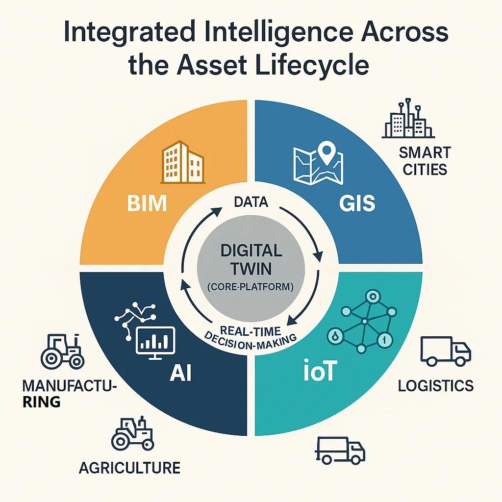
Digital transformation is no longer a strategic option, it is a necessity. Industries across the board, from construction and manufacturing to agriculture and logistics, are facing increasing pressure to optimize performance, improve decision-making, and respond rapidly to change. At the core of this transformation lies the convergence of four powerful technologies: Building Information Modeling (BIM), Geographic Information Systems (GIS), the Internet of Things (IoT), and Artificial Intelligence (AI). While each offers immense value on its own, their real power is unlocked when they are integrated into a unified digital ecosystem.
This article explores why this integration matters, how it works, and what benefits it brings to industries striving to stay competitive in the Fourth Industrial Revolution.
The Four Pillars of Digital Integration
1. BIM (Building Information Modeling): BIM provides detailed digital representations of buildings and infrastructure, incorporating geometry, spatial relationships, and metadata. It supports the lifecycle of a project, from planning and design to construction and maintenance, offering a centralized platform for collaboration.
2. GIS (Geographic Information Systems): GIS captures, stores, and analyzes spatial and geographic data. It allows organizations to contextualize infrastructure within the real world, mapping terrain, utilities, environmental factors, and regulatory zones. It is critical for site selection, environmental analysis, and urban planning.
3. IoT (Internet of Things): IoT connects sensors, machines, and devices, enabling the real-time collection of data from physical environments. These devices can monitor temperature, humidity, motion, vibration, energy consumption, and more, delivering continuous feedback loops to digital platforms.
4. AI (Artificial Intelligence): AI turns raw data into actionable insights. Through machine learning, computer vision, and predictive analytics, AI enables systems to detect patterns, forecast outcomes, automate workflows, and support intelligent decision-making.
Why Integration Matters
Siloed technologies create fragmented workflows.
Without integration, data remains locked within departmental silos, GIS in urban planning, BIM in architecture, IoT in operations, and AI in research. This fragmentation leads to inefficiencies, duplicated efforts, and missed opportunities. When integrated, these technologies create a common data environment (CDE) that enables seamless collaboration across the asset lifecycle.
Contextualized intelligence is key.
A BIM model shows how a facility is built. GIS shows where it is built. IoT shows how it’s performing. AI tells us what to do next. Only when all four work together can we understand the “what,” “where,” “how,” and “why” of operations in real-time.
Cross-sector value is amplified.
This integration drives value across diverse sectors:
In construction, it enables 4D/5D simulations with geospatial context and real-time construction monitoring.
In manufacturing, it creates digital twins of plants for predictive maintenance and performance optimization.
In agriculture, it links crop performance with satellite data, soil sensors, and AI-powered weather prediction.
In the supply chain, it maps logistics routes, monitors warehouse conditions, and forecasts delays using AI.
Real-World Impact: Use Case Examples
Smart Cities: By integrating BIM, GIS, IoT, and AI, city planners can simulate future urban growth, optimize traffic flows, monitor pollution levels, and coordinate emergency response. For instance, digital twins of city infrastructure can simulate flood scenarios and guide climate-resilient planning.
Infrastructure Asset Management: Road networks, bridges, and utility systems can be continuously monitored using IoT sensors. GIS provides the location data, BIM delivers the structural model, and AI analyzes sensor data for early warnings on degradation or failure.
Green Buildings and Energy Management: A building equipped with IoT sensors feeds data into the BIM model, tracking occupancy, lighting, HVAC usage, and more. AI then optimizes energy consumption patterns. When combined with GIS, this data helps compare performance across geographic zones and climate conditions.
Precision Agriculture: GIS maps soil characteristics, topography, and crop zones. IoT devices monitor moisture levels and weather. AI algorithms analyze trends to recommend irrigation schedules or detect pest outbreaks early. A digital twin of the farm could simulate different planting strategies based on past yield and current conditions.
The Technical Backbone: How It Works
Data Interoperability and Standards: Open data standards (like IFC for BIM, GeoJSON for GIS, MQTT for IoT, and ONNX for AI models) are essential for enabling integration. Middleware platforms and APIs help link systems together in real-time.
Cloud Infrastructure and Edge Computing: Cloud platforms allow scalable storage and compute power for integrated digital ecosystems. Edge computing supports local decision-making in latency-sensitive environments like industrial plants or field sensors.
Digital Twins as Integration Frameworks: A digital twin acts as a live, interactive replica of an asset or process. It synchronizes BIM for structure, GIS for location, IoT for data, and AI for intelligence, offering a single pane of glass for asset performance and forecasting.
Industry Trends Driving This Integration
The following trends are accelerating the need for this convergence:
Urbanization and the need for resilient infrastructure
Decarbonization goals, driving energy-efficient designs
Supply chain shocks, requiring agile, data-driven logistics
Labor shortages, demanding automation and remote monitoring
ESG reporting, requiring traceable and verifiable data across operations
In addition, regulatory mandates and industry certifications increasingly require digital documentation, traceability, and data transparency, outcomes that integration supports directly.
Challenges and How to Overcome Them
1. Data Silos and Legacy Systems: Many organizations struggle to bridge legacy systems with modern platforms. A phased integration plan, supported by middleware and data connectors, helps transition without disrupting operations.
2. Lack of Skilled Workforce: Successful integration requires cross-disciplinary expertise. Upskilling and collaborative partnerships with technology vendors, academic institutions, and innovation hubs can help bridge this gap.
3. Cybersecurity Risks: More connected systems mean more vulnerability points. A robust cybersecurity framework, including encryption, access controls, and monitoring, is essential for safeguarding integrated environments.
4. High Upfront Investment: While initial costs can be high, long-term ROI justifies the investment. Modular deployment, starting with one use case and scaling, can help demonstrate early value.
What the Future Holds
The future is heading toward autonomous ecosystems, where systems self-optimize based on real-time data, simulations, and predictive insights. Integration of BIM, GIS, IoT, and AI is the foundation for this shift.
Emerging capabilities such as:
AI co-pilots for construction planning
Real-time immersive XR environments using BIM and GIS
Swarm robotics coordinated through IoT and AI
Blockchain-based digital twins for data integrity
...are all built on this interconnected stack.
Conclusion
The integration of BIM, GIS, IoT, and AI is not just about connecting technologies, it’s about connecting decisions, people, and outcomes. It enables organizations to operate smarter, respond faster, and plan better. In a world where disruption is constant and competition is global, those who integrate will lead.
This is not the future. This is now.