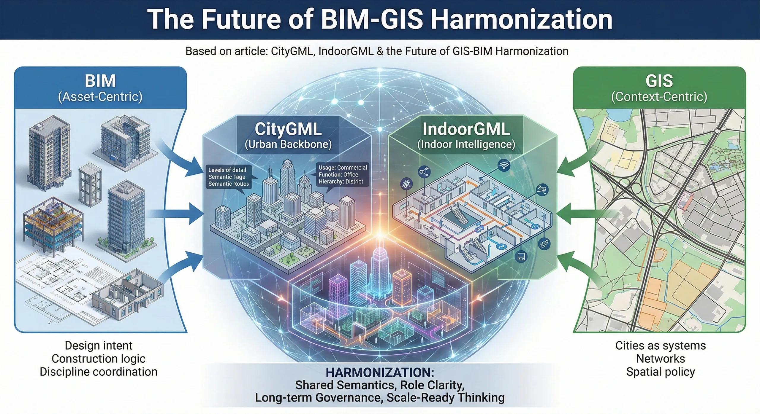
Most BIM–GIS integrations today work because teams force alignment through exports, plugins, or custom pipelines.
That works, for projects.
But cities, campuses, airports, hospitals, and national infrastructure need something stronger than ad-hoc integration. They need shared semantics , not just shared geometry.
This is where CityGML and IndoorGML matter, not as file formats, but as coordination languages between BIM and GIS.
1. Why BIM–GIS Integration Keeps Breaking at Scale
At small scale, integration succeeds because:
Teams know the context
Models are short-lived
Assumptions are manageable
At scale, integration fails because:
Semantics are inconsistent
Geometry means different things in different systems
Indoor and outdoor worlds don’t align
Updates break downstream systems
The problem isn’t tooling. It’s lack of a common information model .
2. CityGML: The Missing Urban Backbone
CityGML is designed to represent:
Cities as systems, not projects
Buildings in their urban context
Multiple Levels of Detail (LoD)
Semantics like usage, function, and hierarchy
Why this matters:
BIM models are asset-focused
CityGML is context-focused
CityGML doesn’t compete with BIM.
It hosts BIM-derived assets inside a city-scale logic .
3. IndoorGML: Where Most Digital Twins Still Fail
Most digital twins break down indoors.
IndoorGML addresses:
Indoor navigation
Connectivity between spaces
Movement logic, not just geometry
Relationship between rooms, corridors, stairs, and exits
Why this matters:
BIM knows what a room is
GIS needs to know how people move through it
IndoorGML bridges engineering structure with human behavior .
4. Geometry Is Easy. Semantics Is Hard.
Most integrations focus on:
Coordinates
File formats
Visualization
The real challenge is:
What is a “space”?
What is a “level”?
What is “public access” vs “restricted”?
What changes over time, and what doesn’t?
CityGML and IndoorGML focus on meaning , not appearance.
5. Why This Matters for Digital Twins
A digital twin without harmonized semantics:
Looks impressive
Breaks during updates
Can’t scale across departments
Becomes project-bound
With harmonization:
Buildings connect to districts
Indoors connect to outdoors
Assets connect to policy
Decisions persist beyond projects
This is how twins become platforms , not demos.
6. BIM Will Always Be Asset-Centric (And That’s Fine)
BIM is excellent at:
Design intent
Construction logic
Discipline coordination
But BIM was never meant to:
Represent cities
Manage networks
Support long-term spatial policy
Forcing BIM to do this creates fragile systems.
Harmonization means letting each system do what it’s best at .
7. GIS Needs Indoor Intelligence to Stay Relevant
GIS without indoor intelligence:
Misses human-scale behavior
Stops at building shells
Can’t support operations
IndoorGML allows GIS to:
Enter buildings meaningfully
Support navigation and safety
Connect operational systems
This is essential for campuses, metros, hospitals, and airports.
8. India Context: Why This Conversation Is Early but Necessary
In India:
Most projects are still delivery-focused
Asset handover standards are evolving
Urban digital twins are emerging
This is the right time to:
Design harmonization into platforms
Avoid tool-driven lock-in
Think beyond immediate project needs
Waiting until scale arrives makes correction expensive.
9. The Future Is Not One Model
The future is:
Multiple models
Shared semantics
Clear roles
Governed exchange
CityGML and IndoorGML are not “the answer.”
They are foundations for asking the right questions .
10. A Simple Harmonization Rule
If two systems show the same building but disagree on what it means, integration has already failed.
Conclusion
The future of BIM–GIS integration is not about better exporters.
It is about:
Semantic alignment
Role clarity
Long-term governance
Scale-ready thinking
CityGML and IndoorGML signal a shift:
From model-centric thinking
To system-centric intelligence
That shift is what will separate digital twins that last from those that fade after project closeout.