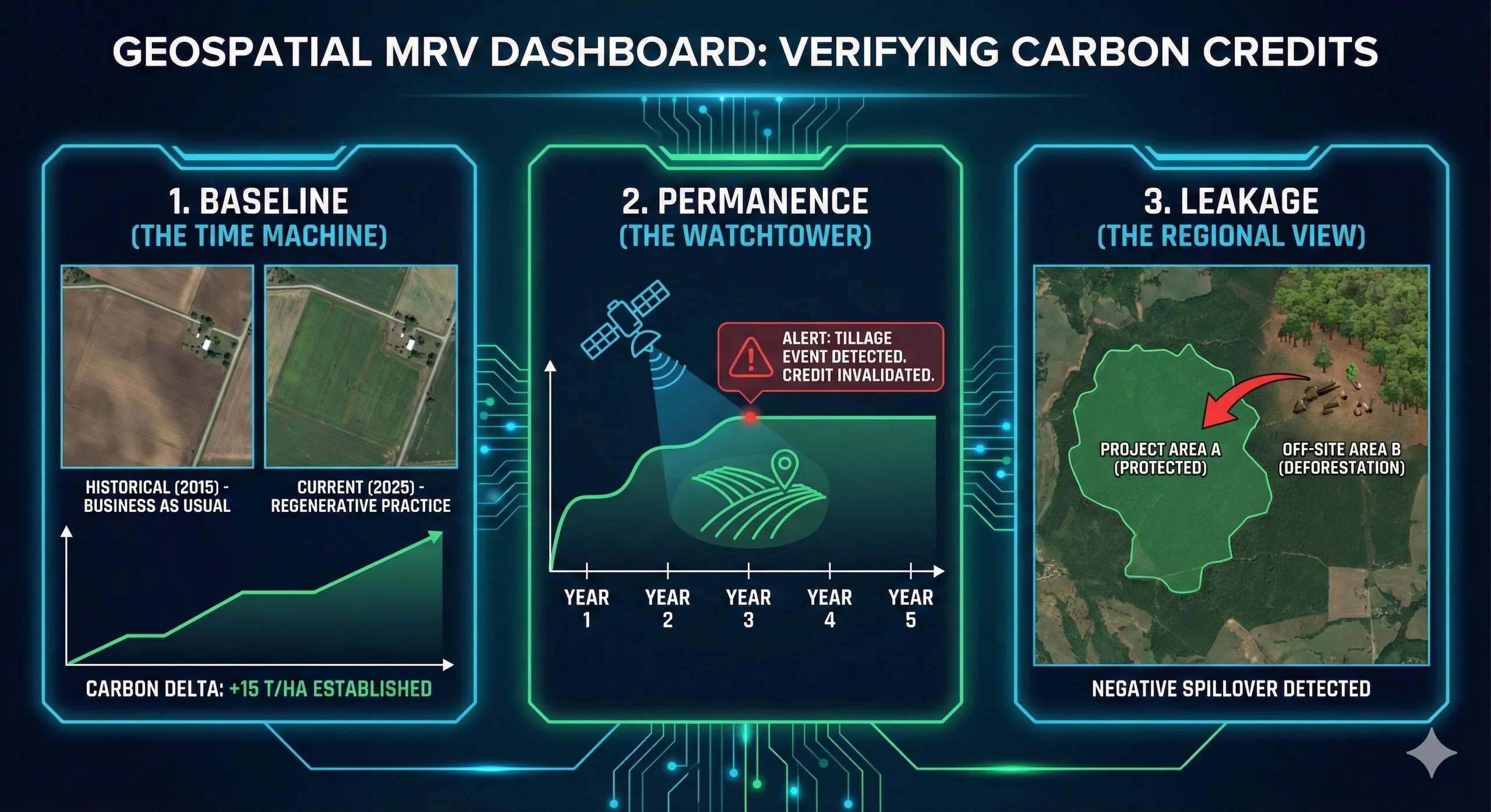
What if farmers could earn from carbon, but only if we can measure, verify, and trust the carbon gains?
Carbon farming promises new income streams for farmers, improved soil health, and climate mitigation.
But none of it works without robust MRV , Measurement, Reporting, and Verification.
MRV is the backbone of carbon markets.
It determines whether carbon was actually stored in soil or biomass, whether it will stay there, and whether actions unintentionally caused emissions elsewhere.
This article decodes the three non-negotiables of carbon market integrity:
Baselines, Permanence, and Leakage , and how geospatial intelligence makes them measurable.
1️⃣ Carbon Farming as a Measurable System
Carbon farming revolves around two quantifiable pools:
A. Soil Organic Carbon (SOC)
Enhanced by:
residue retention
reduced tillage
cover crops
organic amendments
compost/biochar
regenerative practices
B. Aboveground Biomass (AGB)
Driven by:
agroforestry
perennial crops
hedgerows
silvopasture
We are not just observing crops, we are observing carbon flow across soil, vegetation, and atmosphere.
2️⃣ MRV: The Core Challenge
MRV must answer three questions:
Was carbon added? (Measurement)
Can we trust the numbers? (Reporting)
Will it stay in place? (Verification)
Geospatial datasets, field sampling, machine learning, and process models combine to ensure the answers are accurate, scalable, and transparent .
3️⃣ Baselines, The Starting Carbon Level
A baseline is the carbon stock before interventions begin .
It defines what “additional carbon” actually means.
A. Baseline Methods
1. Direct Soil Sampling (Gold Standard)
stratified random sampling
SOC lab analysis
0–15 cm, 15–30 cm depth layers Used for calibration.
2. Remote Sensing–Derived Baselines
Sentinel-2 red edge for biomass
hyperspectral (PRISMA) for SOC inference
LiDAR for canopy carbon
NDVI/EVI trends for prior vegetation condition
3. Model-Based Baselines
Process models like RothC, CENTURY, DNDC assess:
historic land use
soil type
climate
management patterns
B. Why Baselines Matter
Without a baseline, carbon claims are meaningless.
With weak baselines, they become unreliable.
A scientifically defensible baseline is the foundation of credit integrity .
4️⃣ Permanence, Will the Carbon Stay?
Carbon is only valuable if it stays stored for 20–30 years (or longer).
But SOC and biomass can be lost quickly due to:
tillage
drought
crop burning
erosion
land-use change
pest outbreaks
overgrazing
A. Measuring Permanence Geospatially
SAR time-series → tillage detection
NDVI anomalies → biomass loss
fire alerts → burning events
DEM + rainfall → erosion risk
land-use change → forest-to-agri conversions
B. Buffer Pools
Credits are discounted (5–20%) to protect against future carbon loss.
Higher-risk regions → larger buffers.
C. Management Practices Permanence Score
Some practices store carbon faster but lose it quickly.
Others store slower but are more stable.
A permanence score helps carbon programs design long-term resilient pathways .
5️⃣ Leakage, Did emissions shift elsewhere?
Leakage occurs when carbon gains in one area cause emissions in another.
Types of Leakage
A. Activity-Shifting Leakage
Example: Farmer stops tilling Field A → increases tilling on Field B.
B. Market Leakage
Reduced crop area → reduced supply → higher prices → increased cultivation elsewhere.
C. Livestock Leakage
Agroforestry adoption → reduced grazing land → expansion into new areas.
Detecting Leakage with GIS
land-use maps (Sentinel-2, Landsat)
cropping pattern changes
forest loss near project boundaries
livestock density maps
expansion of cultivation in adjacent villages
Leakage is the hardest MRV challenge, but geospatial analytics makes it detectable.
6️⃣ RS + ML Pipelines for Carbon MRV
A complete MRV system integrates:
A. Soil Layers
SOC maps (RS + ML + lab calibration)
moisture layers
erosion risk
soil type, texture, bulk density
B. Vegetation Layers
NDVI/EVI/NDRE time-series
LiDAR-derived canopy height
biomass allometry
C. Activity Data
tillage events
residue retention
irrigation scheduling
crop type + rotation
D. Climate Inputs
rainfall
temperature
ET
extremes
E. Carbon Models
RothC
CENTURY
IPCC Tier 2/3 equations
biomass expansion factors
F. Verification Tools
high-res imagery (1–3 m)
UAV scans
field sampling tracks
MRV shifts from manual reporting → continuous monitoring .
7️⃣ India: Carbon MRV Is Becoming Essential
India’s soil carbon opportunity is massive:
140+ million hectares of farmland
degraded soils
low SOC (<0.5% in many districts)
active regenerative agriculture programs
growing interest in carbon markets
need for farmer incentives
But Indian projects require transparent MRV to gain credibility.
Geospatial MRV provides:
district-level SOC baselines
field-level carbon change
aggregation for carbon programs
audit-ready evidence
leakage & permanence tracking
This builds trust with buyers and ensures fair payouts to farmers.
8️⃣ Carbon Farming Digital Twin
A Carbon Twin integrates:
soil carbon flux
biomass accumulation
practice adoption
emissions reductions
MRV workflows
uncertainty quantification
leakage boundary monitoring
permanence risk layers
Such a twin allows simulations like:
“What if farmers adopt no-till on 30% of plots?”
“How will a drought year impact SOC permanence?”
“Which villages are leakage hotspots?”
This moves carbon farming from estimation → operational intelligence .
Conclusion
Carbon farming succeeds only when its MRV is robust.
Baselines define where we start .
Permanence ensures carbon stays .
Leakage checks whether emissions moved elsewhere .
Geospatial intelligence, field sampling, and carbon models together build MRV systems that are credible, scalable, and fair .
Carbon is not just stored, it must be measured, monitored, and maintained .