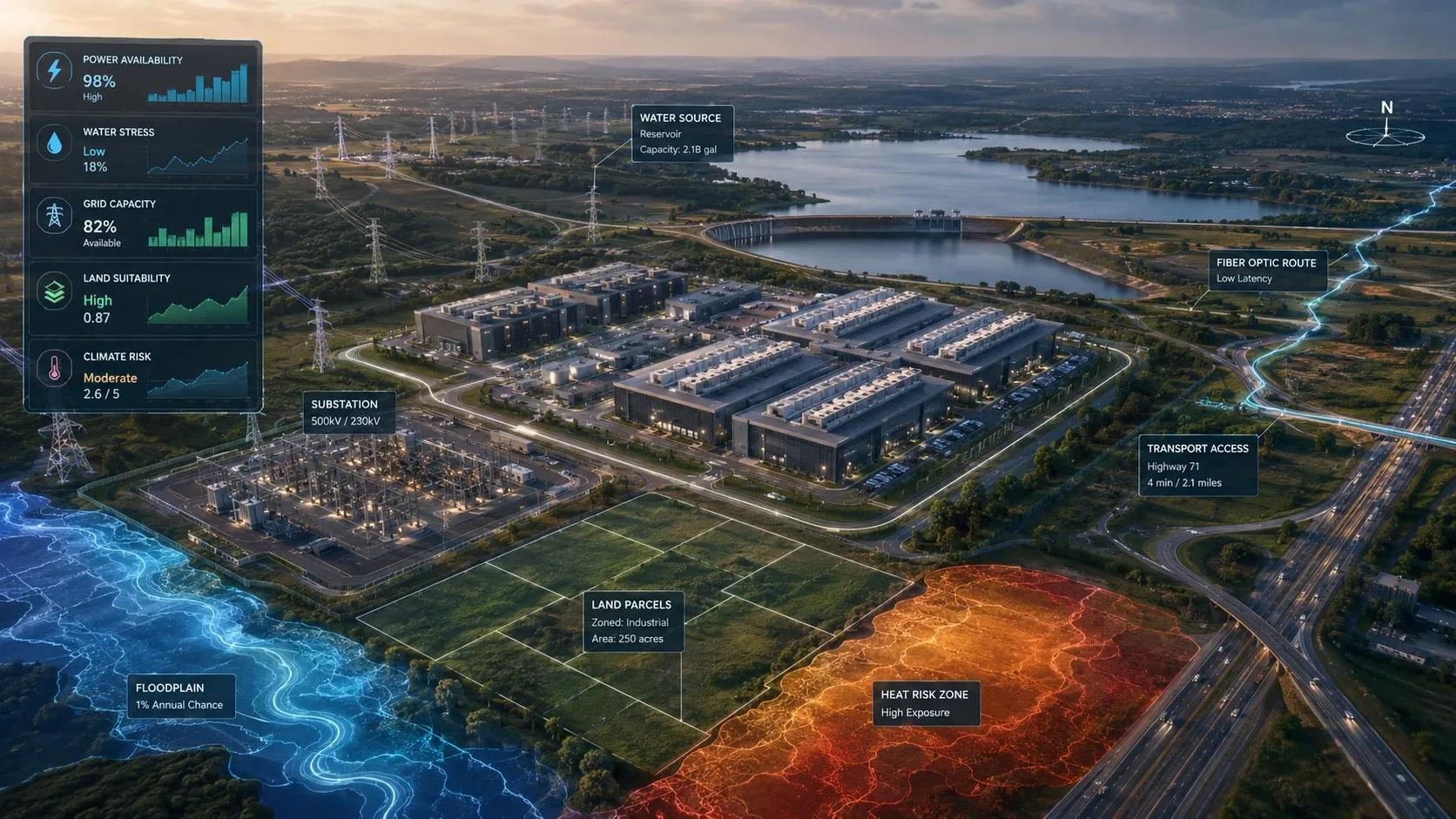
AI may run in the cloud, but the cloud still touches the ground.
Behind every AI model, chatbot, automation workflow, and enterprise AI system is a physical infrastructure layer. That layer needs land, power, water, cooling, grid connectivity, fiber networks, permits, and long-term climate resilience.
This is where the conversation around AI infrastructure is beginning to change.
For the last two years, most AI discussions have focused on models, chips, compute capacity, cloud platforms, and automation. These are important. But as AI demand grows, the bottleneck is no longer only digital.
It is physical.
Where will these data centers be built?
Can the grid support them?
Is water available for cooling?
Is the site exposed to flood, heat, drought, or other climate risks?
Will the land remain suitable for the next 20 to 30 years?
Can the surrounding infrastructure handle the load?
These are not only IT questions.
They are geospatial questions.
AI infrastructure starts with location
A data center is not just a technical facility. It is a land-based infrastructure asset.
It requires a site that can support high energy demand, reliable connectivity, physical security, transport access, cooling infrastructure, environmental compliance, and future expansion.
A location may appear suitable on paper because land is available. But availability is only one layer.
The site may be far from high-capacity power infrastructure.
It may be in a water-stressed region.
It may face future heat stress.
It may be exposed to flooding.
It may require costly transmission upgrades.
It may face local resistance because of land, water, or environmental concerns.
This is why data-center planning cannot be treated only as a real-estate or engineering decision.
It needs spatial intelligence.
The better question is not: where can we build?
The better question is: where can AI infrastructure operate reliably, responsibly, and sustainably over its full lifecycle?
Power is now a spatial constraint
AI data centers need large and continuous power.
As compute demand grows, power availability becomes one of the most important site-selection factors. This means data-center planning must be closely linked with energy geography.
Where are substations located?
Where is transmission capacity available?
Where can renewable energy be integrated?
Which areas already face grid congestion?
Where will future load growth create stress?
Which sites may require dedicated power generation?
These questions cannot be answered through spreadsheets alone.
They require GIS, utility network mapping, grid capacity layers, land-use data, renewable energy potential, environmental constraints, and demand forecasting.
In many regions, power may become the deciding factor between a viable site and a risky site.
This opens a major opportunity for geospatial technology.
The geospatial industry can help data-center developers, utilities, investors, and governments compare sites not only by cost, but by energy readiness, grid resilience, and long-term infrastructure risk.
Water will become a board-level issue
Power gets most of the attention, but water may become equally important.
Data centers produce heat. Cooling systems must manage that heat continuously. Depending on the cooling method and local climate, water availability can become a serious operational constraint.
This is especially important in regions already facing water stress.
A site may have strong power availability but weak water security.
Another site may have good land access but poor cooling conditions.
A location may be viable for one facility but not for a larger data-center cluster.
A site may be safe today but vulnerable under future drought conditions.
These are layered spatial problems.
Water risk assessment must consider surface water, groundwater, rainfall patterns, drought history, competing users, local regulation, heat exposure, and climate projections.
For AI infrastructure, water is not just an environmental concern. It is an operational continuity concern.
If cooling is constrained, compute is constrained.
Climate risk changes the long-term equation
Data centers are long-life infrastructure assets.
This means climate risk must be assessed before site selection, not after construction.
Flood risk, extreme heat, storms, drought, wildfire, and grid disruption can affect uptime, insurance, operating cost, and asset value.
A low-cost site can become expensive if it is exposed to recurring climate hazards.
A fast-growing region can become risky if heat stress increases cooling demand.
A well-connected site can still be vulnerable if access roads, substations, or nearby infrastructure are exposed.
This is where geospatial intelligence becomes investment intelligence.
Satellite data, climate models, terrain analysis, hydrology, land-use change, heat mapping, flood modelling, and infrastructure layers can help decision-makers understand not only current suitability, but future resilience.
The question should not be whether a site works today.
The question should be whether it will remain reliable under future operating conditions.
Grid planning and AI growth must be connected
AI infrastructure does not only consume power. It changes power demand patterns.
When large data centers cluster in specific regions, they can create new pressure on local and regional grids. This affects transmission planning, generation strategy, renewable integration, distribution capacity, and reliability.
This is why AI infrastructure planning must be connected with grid planning.
For governments and utilities, this creates a new challenge: how to support AI growth without creating infrastructure stress.
For investors and developers, it creates another question: which locations can scale without becoming grid-constrained?
For geospatial companies, this creates a clear opportunity.
A spatial decision platform can combine land availability, grid proximity, transmission capacity, renewable energy zones, water stress, climate exposure, fiber connectivity, road access, permitting constraints, and community sensitivity into one decision layer.
This is not just mapping.
This is infrastructure intelligence.
Why this matters for India
India is moving quickly in AI, cloud, digital public infrastructure, smart cities, manufacturing, logistics, fintech, and enterprise automation.
This will increase demand for data centers.
But India’s planning context is complex.
Land is competitive.
Water stress is already a serious concern in many regions.
Urban expansion is fast.
Grid reliability varies by location.
Heat exposure is rising.
Flooding affects many urban and peri-urban areas.
Environmental approvals and local concerns can influence project timelines.
This makes geospatial planning essential.
India cannot afford to build AI infrastructure through isolated site-level decisions. It needs a broader spatial view of where compute infrastructure should grow, how it should connect with energy systems, and how it should manage water and climate risk.
This is where GIS, remote sensing, digital twins, IoT, energy mapping, and climate analytics can work together.
The opportunity is not only to identify land parcels.
The opportunity is to help decision-makers compare locations based on operational readiness and long-term resilience.
From maps to action
The winners in geospatial AI will not be those who visualize the world best, but those who help operators act on it fastest.
For AI data centers, that means helping decision-makers answer practical questions:
Which site should we shortlist?
Which location has the lowest long-term risk?
Where is power available?
Where is water stress acceptable?
Where will climate exposure increase operating cost?
Where does the grid need reinforcement?
Where can approvals move faster?
Where can growth happen without creating avoidable stress?
This is where geospatial AI becomes more than visualization.
It becomes a decision engine.
A strong AI infrastructure siting platform could integrate satellite imagery, land records, grid data, hydrology, climate risk, zoning, renewable potential, transport access, fiber routes, and environmental constraints.
It could score locations.
It could flag risk.
It could compare scenarios.
It could help governments plan better.
It could help investors reduce uncertainty.
It could help developers move faster without ignoring sustainability.
That is the real value.
The cloud still depends on the ground
The AI economy is often described as digital, but its foundations are physical.
AI needs compute.
Compute needs data centers.
Data centers need land, power, water, cooling, grids, and resilience.
This is why AI data centers are becoming geospatial problems.
For the geospatial industry, this is a major opportunity.
The next phase of AI infrastructure will need more than cloud architects and chip designers. It will need spatial planners, GIS specialists, climate analysts, utility planners, infrastructure consultants, and decision-intelligence platforms.
Because the future of AI will not only depend on what models can do.
It will also depend on where the infrastructure can safely and sustainably operate.
AI may run in the cloud.
But the cloud still needs a location.